Parkcrest
Neighbourhoods in Burnaby

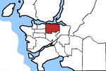
Parkcrest is a hillside neighbourhood in North Burnaby, British Columbia adjacent to Kensington Park which gave it its name. It has a long rectangular shape stretched north to south and is bounded by Springer Avenue to the west and Kensington Avenue to the east. To the north its border runs along Hastings Street, its southern border lies along the Lougheed Highway and Skytrain tracks. Its elevation gradually lowers to the south and ends up in Central Valley, quite low above the level of Burnaby Lake.
Excerpt from the Wikipedia article Parkcrest (License: CC BY-SA 3.0, Authors, Images).Parkcrest
Charles Street, Burnaby
Geographical coordinates (GPS) Address Nearby Places Show on map
Geographical coordinates (GPS)
| Latitude | Longitude |
|---|---|
| N 49.2726 ° | E -122.979 ° |
Address
Charles Street
Charles Street
V5B 3V8 Burnaby
British Columbia, Canada
Open on Google Maps


