Tai Tam Country Park

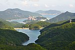
Tai Tam Country Park (Chinese: 大潭郊野公園; Jyutping: daai6 taam4 gaau1 je5 gung1 jyun4) is a country park in the Tai Tam area in the south end of Hong Kong Island. At 1,315 hectares (3,250 acres), the park consists of one fifth of Hong Kong Island's land mass. During World War II, the Japanese encountered strong resistance from British defence forces here. So that the park preserves bloody memories from that period.The park was designated in 1977 with attractions like: Jardine's Lookout Tai Tam Upper Reservoir Tai Tam Byewash Reservoir Tai Tam Tuk Reservoir Tai Tam Intermediate Reservoir Tai Tam Forts Mount Parker, the second highest peak (531 m (1,742 ft)) on Hong Kong Island Mount ButlerGranite rocks in the north and volcanic rocks in the south form the geological composition of this area.Another country park adjacent to it, named Tai Tam Country Park (Quarry Bay Extension), was designated in 1979.
Excerpt from the Wikipedia article Tai Tam Country Park (License: CC BY-SA 3.0, Authors, Images).Tai Tam Country Park
Tai Tam Family Walk, Hong Kong Island
Geographical coordinates (GPS) Address Nearby Places Show on map
 Continue reading on Wikipedia
 Geographical coordinates (GPS)
| Latitude | Longitude |
|---|---|
| N 22.25701 ° | E 114.20262 ° |
Address
大潭家樂徑 Tai Tam Family Walk
Tai Tam Family Walk
Hong Kong Island (Southern District)
Hong Kong, China
Open on Google Maps