place

Wong Nai Chung Gap

Hong Kong geography stubsUse Hong Kong English from July 2017Wong Nai Chung Gap
Wong Nai Chung Gap 2017

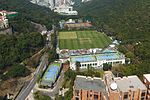
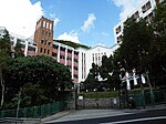
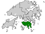
Wong Nai Chung Gap (Chinese: 黃泥涌峽; lit. 'The gorge that yellow mud is gushing out of') is a geographic gap in the middle of Hong Kong Island in Hong Kong. The gap is between Mount Nicholson and Jardine's Lookout behind Wong Nai Chung (Happy Valley). Five roads meet at the Gap: Wong Nai Chung Gap Road, Tai Tam Reservoir Road, Repulse Bay Road, Deep Water Bay Road and Black's Link. It is a strategic passage between the north and south of the island, though less so today since the opening of the Aberdeen Tunnel.

Excerpt from the Wikipedia article Wong Nai Chung Gap (License: CC BY-SA 3.0, Authors, Images).

Wong Nai Chung Gap
Wong Nai Chung Gap Road, Hong Kong Island Wong Nai Chung Gap (Wan Chai District)

Geographical coordinates (GPS) Address Nearby Places
placeShow on map

Wikipedia: Wong Nai Chung GapContinue reading on Wikipedia

Geographical coordinates (GPS)

Latitude Longitude
N 22.25723 ° E 114.19245 °
placeShow on map

Address

黃泥涌峽道 Wong Nai Chung Gap Road

Wong Nai Chung Gap Road
Hong Kong Island, Wong Nai Chung Gap (Wan Chai District)
Hong Kong, China
mapOpen on Google Maps

Wong Nai Chung Gap 2017
Share experience

Nearby Places

Hong Kong Island
Hong Kong Island

Hong Kong Island is an island in the southern part of Hong Kong. It has a population of 1,289,500 and its population density is 16,390/km2, as of 2008. The island had a population of about 3,000 inhabitants scattered in a dozen fishing villages when it was occupied by the United Kingdom in the First Opium War (1839–1842). In 1842, the island was formally ceded in perpetuity to the UK under the Treaty of Nanking and the City of Victoria was then established on the island by the British Force in honour of Queen Victoria. The Central area on the island is the historical, political and economic centre of Hong Kong. The northern coast of the island forms the southern shore of the Victoria Harbour, which is largely responsible for the development of Hong Kong due to its deep waters favoured by large trade ships. The island is home to many of the most famous sights in Hong Kong, such as "The Peak", Ocean Park, many historical sites and various large shopping centres. The mountain ranges across the island are also famous for hiking. The northern part of Hong Kong Island, together with Kowloon and Tsuen Wan New Town, forms the core urban area of Hong Kong. Their combined area is approximately 88.3 square kilometres (34.1 square miles) and their combined population (that of the northern part of the island and of Kowloon) is approximately 3,156,500, reflecting a population density of 35,700/km2 (91,500/sq. mi.). The island is often referred to locally as "Hong Kong side" or "Island side". Suffix "side" applied to other locations (e.g. China-side and Kowloon Walled City-side), the sole remnant of which is "Kowloon side" when indicating the two sides of the harbour. The form was once more common in Britain than now, such as south/Surrey-side and endures in British placenames like Cheapside, Tyneside, and Teesside, not all of which have an obvious watercourse or boundary.

Wilson Trail
Wilson Trail

The Wilson Trail (Chinese: 衛奕信徑) is a 78-kilometre (48 mi) long-distance footpath in Hong Kong, 63 km of which runs through Hong Kong country parks. It was named after David Wilson, Baron Wilson of Tillyorn, who was Governor of Hong Kong from 1987 to 1992. The Wilson Trail was developed by Friends of the Country Park and sponsored by various private organisations. The construction work of the trail began in 1994. The Wilson Trail was first opened on 21 January 1996. In all, the Wilson Trail traverses eight of the Country Parks. On Hong Kong Island, Tai Tam Country Park and the adjacent Quarry Bay Country Park begin the journey. Across the harbour, there is a gap where the trail runs through hills outside the parks. Then come the three parks named Ma On Shan, Lion Rock, and Kam Shan. In the central New Territories, the Wilson Trail heads north through Shing Mun Country Park and Tai Mo Shan Country Park. Finally it climbs into the majestic Pat Sin Leng Country Park. Each of the Country Parks the Wilson Trail traverses has its individual character and appeal – offering, as one proceeds from south to north, changing settings with much of interest.The trail is aligned north-south and runs from Stanley, in the south of Hong Kong Island to Nam Chung, in the northeastern New Territories. Of the four long-distance trails, the Wilson Trail is the newest. Since the trail crosses Victoria Harbour, it makes use of the MTR or buses.