place

Hendaye

Beaches of Metropolitan FranceCommunes of Pyrénées-AtlantiquesFrance–Spain border crossingsLabourdPages with French IPA
Pages with disabled graphsPort cities and towns on the French Atlantic coastSeaside resorts in FranceVague or ambiguous time from October 2018Vauban fortifications in France
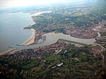
Hendaye, 20.3.06
Hendaye, 20.3.06

Hendaye (French pronunciation: [ɑ̃daj]; Basque: Hendaia, Spanish: Hendaya) is a commune in the Pyrénées-Atlantiques department and Nouvelle-Aquitaine region of southwestern France.The town, Metropolitan France's most southwesterly and a popular seaside tourist resort, stands on the right bank of the River Bidassoa – which marks the Franco-Spanish border – at the point where it empties into the Atlantic Ocean in the French Basque Country. Hendaye has three distinguishable parts: la ville (the town), which stretches from Saint Vincent's church to the area around the SNCF railway station and the industrial zone; la plage (the beach), the seaside quarter; and les hauteurs (the heights), the villas and camping sites on the hills between and behind the other two areas.

Excerpt from the Wikipedia article Hendaye (License: CC BY-SA 3.0, Authors, Images).

Hendaye
Passage Ouristycolanda, Bayonne

Geographical coordinates (GPS) Address Nearby Places
placeShow on map

Wikipedia: HendayeContinue reading on Wikipedia

Geographical coordinates (GPS)

Latitude Longitude
N 43.36 ° E -1.77 °
placeShow on map

Address

Passage Ouristycolanda
64700 Bayonne, Urrizti
Nouvelle-Aquitaine, France
mapOpen on Google Maps

Hendaye, 20.3.06
Hendaye, 20.3.06
Share experience

Nearby Places

Siege of Fuenterrabía (1523–1524)

The siege of Fuenterrabía took place in 1523 when the Franco-Navarrese army had taken it in a new incursion after the failure of the third attempt to reconquer the Kingdom of Navarre, which had been occupied since 1512 by troops from the unified Crown of Castile and Crown of Aragon, with Navarrese support. There were Navarrese on both sides. The Fuenterrabía of the 16th century also included most of the municipal term of the current city of Irun, the municipality of Lezo, and parts of Hendaye, Urruña (Behovia neighborhood) and Pasajes (Pasajes de San Juan). The town and fortress were located on a hill surrounded by thick walls, mountains and the sea at the mouth of the Bidasoa River.Its border situation and its geographic characteristics made both Charles V, Holy Roman Emperor and Francis I of France covet its possession. For this reason, both nations appointed commissioners to elucidate the problems of water limits in the conflicts of the towns of Fuenterrabía and Hendaye, something that until then had been solved by agreement. In 1512, the first counteroffensive was carried out to recover the kingdom of Navarre after its invasion by the Crowns of Castile and Aragon, in which Marshal Pedro de Navarre with 2000 men within the contingent of Lautrec and Borbón were stopped by Luis I of the Cave, II Lord of Solera. To prevent another invasion, the fortification proceeded, ordering in November of that year the construction of a castle in Behovia, which reinforced the effectiveness of the Fuenterrabía fort. As of 1517, the territorial rights of the area were defined by law by the two kingdoms, that of Spain and that of France, leaving the natives divided.

Bidasoa
Bidasoa

The Bidasoa (Spanish: [biðaˈsoa]; French: Bidassoa, pronounced [bidasɔa]) is a river in the Basque Country of northern Spain and southern France that runs largely south to north. Named as such downstream of the village of Oronoz-Mugairi (municipality of Baztan) in the province of Navarre, the river actually results from the merger of several streams near the village Erratzu, with the stream Baztan that rises at the north-eastern side of the mount Autza (1,306 m) being considered the source of the Bidasoa. It joins the Cantabrian Sea (Bay of Biscay) between the towns of Hendaye and Hondarribia. The river is best known for establishing the borderline at its lower tract. This stretch is crossed not only by aircraft at low height but by important European communication axes, namely AP8 E5 E80 - E70 A63 (motorway, connection at the Biriatu toll), main roads N1 - N10 (connection at the roundabout of Saizar by the river) and major French and Spanish railway networks,—Renfe and SNCF. Besides these major lines, other regional ones cross it too, e.g. regional railway EuskoTren (terminus in Hendaye) and another double bridge (pedestrians/vehicles) joining the towns on the border, i.e. the historical Santiago Bridge (Way of St. James). At this stage of the river, urban landscape prevails (built-up area). Before pouring its waters into the ocean, it forms a bay called Txingudi located between these towns and Irun, the site being designated Wetland of International Importance in 2002, with a total area of 1.28 km2 (0.49 sq mi). The banks of Hondarribia hold the minor San Sebastian Airport serving domestic flights and currently mired in controversy over its lengthening and upgrading scheme.