place

Brooklands Lagoon

Geography of ChristchurchLagoons of New ZealandWetlands of Canterbury, New Zealand
Black Swans 27
Black Swans 27

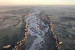
Brooklands Lagoon is technically a very elongated estuary near Brooklands, Christchurch. The Styx river drains into it and it is at the mouth of the Waimakariri river. The Waimakariri used to drain out of Brooklands Lagoon towards the Spencer Park end. This changed when engineers dug through the sand dunes to provide a more direct course to the sea in 1930 in order to reduce the risk of flooding from the Waimakariri River. The Lagoon is protected from the Pegasus Bay (and the sea) by Brooklands Spit. To the south of it is Bottle Lake Forest and Spencer Park. The lagoon is approximately 270 hectares in size, 4.5 kilometers long and 800 meters at its widest. Spring tides will bring approximately 1.6 million cubic meters of water into the lagoon.It was frequently used by the locals prior to the 2010 and 2011 Christchurch earthquakes, where most of Brooklands was red zoned and effectively wiped off the map.

Excerpt from the Wikipedia article Brooklands Lagoon (License: CC BY-SA 3.0, Authors, Images).

Brooklands Lagoon
Waimakari Spit (orange track), Christchurch Brooklands (Coastal-Burwood Community)

Geographical coordinates (GPS) Address Nearby Places
placeShow on map

Wikipedia: Brooklands LagoonContinue reading on Wikipedia

Geographical coordinates (GPS)

Latitude Longitude
N -43.414 ° E 172.707 °
placeShow on map

Address

Waimakari Spit (orange track)

Waimakari Spit (orange track)
Christchurch, Brooklands (Coastal-Burwood Community)
Canterbury, New Zealand
mapOpen on Google Maps

Black Swans 27
Black Swans 27
Share experience

Nearby Places

Bottle Lake, New Zealand

Bottle Lake is a suburb in the north-east of Christchurch with a low number of residents. Most of the suburb is covered by Bottle Lake Forest, which has since the mid-1970s become a popular recreation area. The area was known as Waitikiri to Māori and the swamplands around a lake was a traditional mahinga kai (food gathering place). Bottle Lake was first granted for grazing in 1853. The area was bought as a sheep run by John McLean in 1860. He sold the land after only two years to Edward Reece, who named his homestead Waitikiri after the Māori name for the area. Reece commissioned John Gibb to paint Bottle Lake about 20 years after he purchased the land. Reece died in 1885, and the painting was gifted to the Canterbury Society of Arts in 1902 by his son, William Reece. The oil painting is today owned by the Christchurch Art Gallery.Most of the area was purchased in 1878 by Christchurch City Council for waste disposal, but grazing continued into the next century. The pine plantation was begun in 1912, and the land was drained. By the late 1930s, the lake had dried up. The name of the lake was used for other purposes. The hospital board looked for a remote area where an infectious diseases hospital could be set up, and they established the Bottle Lake Hospital. This has since been renamed Burwood Hospital. The road leading to the hospital was originally called Bottle Lake Road and has since been changed to Burwood Road. The suburb that formed around the hospital took its later name—Burwood.The production forest was out of bounds, and the area was virtually unknown to Christchurch people. This changed in 1975, when the forest was given park status. It has since developed into a recreation area, with mountain biking, horse riding, and walking all very popular. There is some housing on the fringes of Bottle Lake Forest, and Waitikiri Drive is a reminder of the area's original name. The former landfill site within Bottle Lake was reopened after the February 2011 Christchurch earthquake to take an estimated 4.5 million tonnes of demolition material.

Kaiapoi
Kaiapoi

Kaiapoi is a town in the Waimakariri District of the Canterbury region, in the South Island of New Zealand. The town is located approximately 17 kilometres north of central Christchurch, close to the mouth of the Waimakariri River. It is considered a satellite town of Christchurch and is part of the Christchurch functional urban area.Kaiapoi is known for its substantial precolonial pā, Te Kōhaka-a-kaikai-a-waro, established by powerful Kāi Tahu nobleman Tūrākautahi. One of the sons of the powerful rangatira Tūāhuriri, Tūrākautahi exerted vast influence over historical Ōtautahi (the site of modern-day Christchurch). His family controlled the pā he established in the area until it was sacked in 1831 by Te Rauparaha and his followers. The pā was one of the greatest centre of knowledge, economics and natural resources, with a highly complex social structure. All decisions were undertaken by the nobility, who consulted with highly skilled tohunga. In selecting the pā site, Tūrākautahi determined that food (kai) would need to be poi ("swung in"- swung over the pā's protective walls via rope, and also because it lay in the middle of a swamp) from other places. This is how Kaiapoi got its name, and can translated as a metaphor for "economics"Kaiapoi suffered extensive damage in the 2010 Canterbury and also the February 2011 Christchurch earthquakes, which rendered many homes uninhabitable and businesses inoperable. Large areas were condemned as part of a residential red zone covering uninhabitable areas.