place

Spencerville, New Zealand

Populated places in Canterbury, New ZealandSuburbs of ChristchurchUse New Zealand English from December 2015
2010 09 06 Spencerville

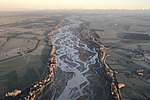
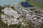
Spencerville is a semi-rural town on the east coast of Canterbury, New Zealand north of Christchurch. The town backs on to Bottle Lake Forest and includes a large (1 hectare) park and 80 hectare camping ground. These amenities, as well as wetlands and an animal and bird park make the town a popular camping area for Christchurch residents.After the 2011 Christchurch earthquake, the New Zealand Government classified Spencerville land as Technical Category T3. This requires repairers, builders and developers to meet stricter building standards.

Excerpt from the Wikipedia article Spencerville, New Zealand (License: CC BY-SA 3.0, Authors, Images).

Spencerville, New Zealand
Heyders Road, Christchurch

Geographical coordinates (GPS) Address Nearby Places
placeShow on map

Wikipedia: Spencerville, New ZealandContinue reading on Wikipedia

Geographical coordinates (GPS)

Latitude Longitude
N -43.432042 ° E 172.69725 °
placeShow on map

Address

Heyders Road 23
8083 Christchurch (Coastal-Burwood Community)
Canterbury, New Zealand
mapOpen on Google Maps

2010 09 06 Spencerville
Share experience

Nearby Places

Bottle Lake, New Zealand

Bottle Lake is a suburb in the north-east of Christchurch with a low number of residents. Most of the suburb is covered by Bottle Lake Forest, which has since the mid-1970s become a popular recreation area. The area was known as Waitikiri to Māori and the swamplands around a lake was a traditional mahinga kai (food gathering place). Bottle Lake was first granted for grazing in 1853. The area was bought as a sheep run by John McLean in 1860. He sold the land after only two years to Edward Reece, who named his homestead Waitikiri after the Māori name for the area. Reece commissioned John Gibb to paint Bottle Lake about 20 years after he purchased the land. Reece died in 1885, and the painting was gifted to the Canterbury Society of Arts in 1902 by his son, William Reece. The oil painting is today owned by the Christchurch Art Gallery.Most of the area was purchased in 1878 by Christchurch City Council for waste disposal, but grazing continued into the next century. The pine plantation was begun in 1912, and the land was drained. By the late 1930s, the lake had dried up. The name of the lake was used for other purposes. The hospital board looked for a remote area where an infectious diseases hospital could be set up, and they established the Bottle Lake Hospital. This has since been renamed Burwood Hospital. The road leading to the hospital was originally called Bottle Lake Road and has since been changed to Burwood Road. The suburb that formed around the hospital took its later name—Burwood.The production forest was out of bounds, and the area was virtually unknown to Christchurch people. This changed in 1975, when the forest was given park status. It has since developed into a recreation area, with mountain biking, horse riding, and walking all very popular. There is some housing on the fringes of Bottle Lake Forest, and Waitikiri Drive is a reminder of the area's original name. The former landfill site within Bottle Lake was reopened after the February 2011 Christchurch earthquake to take an estimated 4.5 million tonnes of demolition material.