Brooklands, Christchurch
Suburbs of ChristchurchUse New Zealand English from February 2020

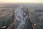
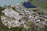
Brooklands is the northernmost suburb of Christchurch, New Zealand. The settlement was built on former swamp land adjacent to Brooklands Lagoon, which forms part of the Waimakariri River mouth. The land damage sustained in the 2010 and 2011 Christchurch earthquakes and subsequent Red Zone classification resulted in the buyout and demolition of nearly all properties in Brooklands, effectively wiping the suburb off the map.
Excerpt from the Wikipedia article Brooklands, Christchurch (License: CC BY-SA 3.0, Authors, Images).Brooklands, Christchurch
Anfield Street, Christchurch Brooklands (Coastal-Burwood Community)
Geographical coordinates (GPS) Address Nearby Places Show on map
 Continue reading on Wikipedia
 Geographical coordinates (GPS)
| Latitude | Longitude |
|---|---|
| N -43.403888888889 ° | E 172.69583333333 ° |
Address
Anfield Street 4
7630 Christchurch, Brooklands (Coastal-Burwood Community)
Canterbury, New Zealand
Open on Google Maps