Runhall
Former civil parishes in NorfolkNorfolk geography stubsSouth NorfolkVillages in Norfolk

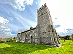
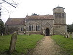
Runhall is a village and former civil parish, now in the parish of Brandon Parva, Coston, Runhall and Welborne, in the South Norfolk district, in Norfolk, England. The parish covers an area of 11.98 km2 (4.63 sq mi) and had a population of 365 in 137 households at the 2001 census, including Welborne and increasing in the 2011 Census to a population of 401 in 148 households. The villages name origin is uncertain possibly, 'tree-trunk nook of land', 'Runa's nook of land', or perhaps, 'council's nook of land'. Its church, All Saints, is one of 124 existing round-tower churches in Norfolk.
Excerpt from the Wikipedia article Runhall (License: CC BY-SA 3.0, Authors, Images).Runhall
Banham Hill, South Norfolk Brandon Parva, Coston, Runhall and Welbourne
Geographical coordinates (GPS) Address Nearby Places Show on map
Geographical coordinates (GPS)
| Latitude | Longitude |
|---|---|
| N 52.62201 ° | E 1.03356 ° |
Address
Banham Hill
Banham Hill
NR9 4DW South Norfolk, Brandon Parva, Coston, Runhall and Welbourne
England, United Kingdom
Open on Google Maps


