Upper Hamble Estuary and Woods

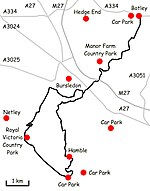
Upper Hamble Estuary and Woods is a 151.2-hectare (374-acre) biological Site of Special Scientific Interest east of Southampton in Hampshire. It is part of Solent and Southampton Water Ramsar site and Special Protection Area, and of Solent Maritime Special Area of Conservation. Part of the site is in Manor Farm Country Park, which is a Local Nature Reserve.This site comprises the upper estuary of the River Hamble, together with adjoining saltmarsh, reedswamp and ancient semi-natural woodland. The woods have a diverse ground flora and invertebrate fauna. There is also a narrow zone of mudflats, with large numbers of marine worms, crustaceans and molluscs, which provide food for birds.
Excerpt from the Wikipedia article Upper Hamble Estuary and Woods (License: CC BY-SA 3.0, Authors, Images).Upper Hamble Estuary and Woods
Strawberry Trail,
Geographical coordinates (GPS) Address Nearby Places Show on map
Geographical coordinates (GPS)
| Latitude | Longitude |
|---|---|
| N 50.897 ° | E -1.28 ° |
Address
Strawberry Trail
Strawberry Trail
SO30 2EQ , Botley
England, United Kingdom
Open on Google Maps


