Le Moyne River
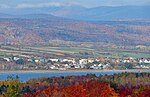
The Le Moyne River generally flows south, on the north shore of the St. Lawrence River, in the municipality of Château-Richer, in the La Côte-de-Beaupré Regional County Municipality in the administrative region of Capitale-Nationale, in the province of Quebec, in Canada. The lower part of this small valley is served by avenue Royale (route 360) and route 138 which runs along the north shore of St. Lawrence River. The Chemin de la Mine, the Montée des Hirondelles and the Montée des Chênes serve the intermediate part to the foot of the moraine. The upper part has mountainous relief and some secondary forest roads, including Chemin Beauséjour, are accessible. Forestry is the main economic activity in this valley; agriculture (lower part) second. The surface of the Le Moyne River is generally frozen from the beginning of December until the end of March; however, safe traffic on the ice is generally from mid-December to mid-March. The water level of the river varies with the seasons and the precipitation; the spring flood occurs in March or April.
Excerpt from the Wikipedia article Le Moyne River (License: CC BY-SA 3.0, Authors).Le Moyne River
Geographical coordinates (GPS) Address Nearby Places Show on map
 Continue reading on Wikipedia
 Geographical coordinates (GPS)
| Latitude | Longitude |
|---|---|
| N 46.9525 ° | E -71.03889 ° |
Address
Quebec, Canada
Open on Google Maps