Rivière du Petit Pré
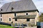
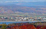
The Rivière du Petit Pré flows south, on the north shore of the Saint Lawrence river, entirely in the municipality of L'Ange-Gardien, in the (MRC) of La Côte-de-Beaupré Regional County Municipality, in the administrative region of Capitale-Nationale, in province of Quebec, in Canada. The lower part of this small valley is served by Avenue Royale and the route 138 which runs along the north shore of the St. Lawrence River. The upper part is accessible by the Lucien-Lefrançois road. Forestry, in particular the exploitation of sugar factories, constitutes the main economic activity in this valley; agriculture (lower part) second. The surface of the Petit Pré river is generally frozen from the beginning of December until the end of March; however, safe traffic on the ice is generally from mid-December to mid-March. The water level of the river varies with the seasons and the precipitation; the spring flood occurs in March or April.
Excerpt from the Wikipedia article Rivière du Petit Pré (License: CC BY-SA 3.0, Authors).Rivière du Petit Pré
Boulevard Sainte-Anne,
Geographical coordinates (GPS) Address Nearby Places Show on map
 Continue reading on Wikipedia
 Geographical coordinates (GPS)
| Latitude | Longitude |
|---|---|
| N 46.92916 ° | E -71.05805 ° |
Address
Camping Turmel
Boulevard Sainte-Anne
G0A 2K0
Quebec, Canada
Open on Google Maps