Sainte-Famille-de-l'Île-d'Orléans
1661 establishments in the French colonial empireIncorporated places in Capitale-NationaleL'Île-d'Orléans Regional County MunicipalityMunicipalities in QuebecPages with non-numeric formatnum arguments ... and 2 more
Quebec City AreaUse Canadian English from January 2023

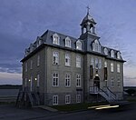
Sainte-Famille-de-l'Île-d'Orléans (Sainte-Famille prior to September 12, 2017) is a municipality in the L'Île-d'Orléans Regional County Municipality, Quebec, Canada, part of the administrative region of Capitale-Nationale. It is situated along the western shores of Island of Orléans. Founded in 1661, Sainte-Famille-de-l'Île-d'Orléans is the oldest settlement on l'île d'Orléans and has one of the most important concentrations of houses of the old French regime.
Excerpt from the Wikipedia article Sainte-Famille-de-l'Île-d'Orléans (License: CC BY-SA 3.0, Authors, Images).Sainte-Famille-de-l'Île-d'Orléans
Chemin Royal,
Geographical coordinates (GPS) Address Nearby Places Show on map
 Continue reading on Wikipedia
 Geographical coordinates (GPS)
| Latitude | Longitude |
|---|---|
| N 46.966666666667 ° | E -70.966666666667 ° |
Address
Domaine de la source a Marguerite
Chemin Royal 2388
Quebec, Canada
Open on Google Maps