Ferrée River (Montmorency River tributary)
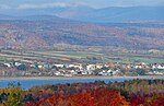
The Ferrée river is a tributary on the east bank of the Montmorency River. It flows in the municipalities of L'Ange-Gardien and Boischatel, in the La Côte-de-Beaupré Regional County Municipality, in the administrative region of Capitale-Nationale, in the province of Quebec, in Canada.The upper part of this valley is served by Chemin des Sucreries, by Chemin du Nord-de-la-Ligne Hydro and by a few forest roads. Forestry, in particular the exploitation of sugar factories, constitutes the main economic activity in this valley; second, recreational tourism. While the lower part crosses the northern sector of the urban part of Boischatel. The surface of the Ferrée river is generally frozen from the beginning of December until the end of March; however, safe traffic on the ice is generally from mid-December to mid-March. The water level of the river varies with the seasons and the precipitation; the spring flood occurs in March or April.
Excerpt from the Wikipedia article Ferrée River (Montmorency River tributary) (License: CC BY-SA 3.0, Authors).Ferrée River (Montmorency River tributary)
Rue de la Sérénité, Quebec Courville (Beauport)
Geographical coordinates (GPS) Address Nearby Places Show on map
 Continue reading on Wikipedia
 Geographical coordinates (GPS)
| Latitude | Longitude |
|---|---|
| N 46.90139 ° | E -71.16944 ° |
Address
Rue de la Sérénité 95
G1C 3L1 Quebec, Courville (Beauport)
Quebec, Canada
Open on Google Maps