Montmorency River

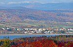
The Montmorency River is a tributary of North-East bank of St. Lawrence river, flowing in the administrative region of Capitale-Nationale, in the province of Quebec, Canada. The course of the river successively crosses the regional county municipality of: MRC La Côte-de-Beaupré Regional County Municipality: Lac-Jacques-Cartier, Château-Richer, L'Ange-Gardien, Boischatel; MRC La Jacques-Cartier Regional County Municipality: Sainte-Brigitte-de-Laval Agglomération de Québec.It drains into the Saint Lawrence River, about 9 kilometres (5.6 mi) downstream from Quebec City. It is especially known for the impressive Montmorency Falls near its mouth. It has an average flow of 35.6 m3/s (1,260 cu ft/s). Typical average summer flow is about 25 m3/s (880 cu ft/s), whereas during spring run-off, the river could swell anywhere from 130 to 650 m3/s (4,600 to 23,000 cu ft/s). Above 770 m3/s (27,000 cu ft/s) is considered an exceptional flood condition, and the Montmorency experienced a record flow of 1,100 m3/s (39,000 cu ft/s) in November 1966.
Excerpt from the Wikipedia article Montmorency River (License: CC BY-SA 3.0, Authors, Images).Montmorency River
Autoroute Dufferin-Montmorency, Quebec Montmorency (Beauport)
Geographical coordinates (GPS) Address Nearby Places Show on map
 Continue reading on Wikipedia
 Geographical coordinates (GPS)
| Latitude | Longitude |
|---|---|
| N 46.885 ° | E -71.143333333333 ° |
Address
Autoroute Dufferin-Montmorency
G1C 1S3 Quebec, Montmorency (Beauport)
Quebec, Canada
Open on Google Maps