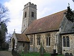
Hellington
Civil parishes in NorfolkHamlets in NorfolkNorfolk geography stubs

Hellington is a hamlet and civil parish in the South Norfolk district of the county of Norfolk, England. In the 2001 census, it contained 24 households and a population of 69.It is centred on a crossroads 1⁄2 mile (4⁄5 km) south of Rockland St. Mary and around 6+1⁄2 miles (10.5 km) southeast of Norwich. The road north leads to Rockland St. Mary, south leads to the church and to Hellington Corner on the A146. East and west from the crossroads are both no through roads. East leads to Hellington Hall, a Grade II Listed 17th-century country house, and Low Common, a Norfolk Wildlife Trust County Wildlife Site. West leads to Holverston.
Excerpt from the Wikipedia article Hellington (License: CC BY-SA 3.0, Authors, Images).Hellington
Hellington Hill, South Norfolk
Geographical coordinates (GPS) Address Nearby Places Show on map
Geographical coordinates (GPS)
| Latitude | Longitude |
|---|---|
| N 52.57734 ° | E 1.41355 ° |
Address
Hellington Hill
Hellington Hill
NR14 7BT South Norfolk
England, United Kingdom
Open on Google Maps


