Mixcoac (archaeological site)

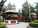
Mixcoac from Nahuatl means "viper in the cloud" is an archaeological zone belonging to the Mexica (Aztec) culture. It was on the shores of Lake Texcoco and in its final stage was under the rule of Tenochtitlan. With the arrival of the Spanish conquistadors, the settlement was practically destroyed to its foundations, which are the only thing that survives of the architecture of the place and can be appreciated today in what is today the San Pedro de los Pinos neighborhood, on the corner of San Antonio avenue and Periférico, in Mexico City. The name Mixcoac, viper of the cloud, could be understood as a representation of the celestial serpent or Milky Way. The occupation of this archaeological area is estimated to have occurred from 900 BC to 1521 AD.
Excerpt from the Wikipedia article Mixcoac (archaeological site) (License: CC BY-SA 3.0, Authors, Images).Mixcoac (archaeological site)
Autopista Urbana Norte, Santa Fe
Geographical coordinates (GPS) Address Nearby Places Show on map
 Continue reading on Wikipedia
 Geographical coordinates (GPS)
| Latitude | Longitude |
|---|---|
| N 19.3863 ° | E -99.1899 ° |
Address
Zona arqueológica de Mixcoac
Autopista Urbana Norte
03800 Santa Fe
Mexico
Open on Google Maps