Mixcoac
Benito Juárez, Mexico CityFormer municipalities of the Mexican Federal DistrictNeighborhoods in Mexico City

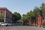
Mixcoac is an area of southern Mexico City which used to be a separate town and municipality within the Mexican Federal District until it was made part of Mexico City proper (the Departamento Central at the time) in 1928. Mixcoac consists of the colonias (official neighborhoods) of Nonoalco, San Juan, Extremadura Insurgentes, Mixcoac, and Insurgentes Mixcoac and is part of the borough of Benito Juárez. It is bounded by Avenida de los Insurgentes to the east and the Periférico freeway to the west, south of Colonia Nápoles and San Pedro de los Pinos. It is a designated Barrio Mágico ("magical neighborhood") of Mexico City.
Excerpt from the Wikipedia article Mixcoac (License: CC BY-SA 3.0, Authors, Images).Mixcoac
Avenida Revolución, Santa Fe
Geographical coordinates (GPS) Address Nearby Places Show on map
 Continue reading on Wikipedia
 Geographical coordinates (GPS)
| Latitude | Longitude |
|---|---|
| N 19.3761 ° | E -99.1877 ° |
Address
Avenida Revolución
Avenida Revolución
03910 Santa Fe
Mexico
Open on Google Maps