Viewbank

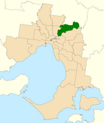
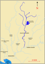
Viewbank is a suburb of Melbourne, Victoria, Australia, 14 km north-east of Melbourne's Central Business District, located within the City of Banyule local government area. Viewbank recorded a population of 7,030 at the 2021 census.The area now known as Viewbank is on the traditional lands of the Wurundjeri people. The Birrarung (Yarra River) and large tracts of the Yarra Valley Parkland run along one border of the suburb. The Plenty River forms Viewbank's eastern boundary, whilst its northern boundary is defined by Lower Plenty Road (a main road linking Heidelberg and Eltham). Although mainly a residential area, there is a small commercial strip on Martins Lane adjacent to Viewbank Primary School.
Excerpt from the Wikipedia article Viewbank (License: CC BY-SA 3.0, Authors, Images).Viewbank
Melissa Court, Melbourne Viewbank
Geographical coordinates (GPS) Address Nearby Places Show on map
Geographical coordinates (GPS)
| Latitude | Longitude |
|---|---|
| N -37.731 ° | E 145.1 ° |
Address
Melissa Court
Melissa Court
3085 Melbourne, Viewbank
Victoria, Australia
Open on Google Maps


