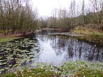
River Lin
Rivers of LeicestershireSoar catchment

The River Lin is a river which runs through North Leicestershire. The source of the river is in Ulverscroft, near Charnwood Forest. The river runs through Bradgate Park before the river runs into the River Soar in Quorn. The river also feeds Cropston Reservoir and Swithland Reservoir. The river runs for around 17 kilometres between its source and confluence with the River Soar. The river is described as one of Leicestershire's shortest rivers.
Excerpt from the Wikipedia article River Lin (License: CC BY-SA 3.0, Authors, Images).River Lin
Leicester Road, Charnwood Quorndon
Geographical coordinates (GPS) Address Nearby Places Show on map
Geographical coordinates (GPS)
| Latitude | Longitude |
|---|---|
| N 52.74318 ° | E -1.16381 ° |
Address
Leicester Road
LE12 8ET Charnwood, Quorndon
England, United Kingdom
Open on Google Maps


