Little Withlacoochee River
Bodies of water of Hernando County, FloridaBodies of water of Sumter County, FloridaFlorida river stubsRivers of Florida

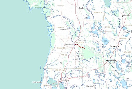
The Little Withlacoochee River is a 16-mile (26 kilometer) long river with its headwaters starting in the Richloam Wildlife Management Area in Sumter County, Florida. The Little Withlacoochee River ends near River Junction Campground just east of Silver Lake in the Croom Wildlife Management Area. It makes up a portion of the Hernando-Sumter County border. Its drainage basin covers 145 mi² (376 km²) of Hernando County and Sumter County.
Excerpt from the Wikipedia article Little Withlacoochee River (License: CC BY-SA 3.0, Authors, Images).Little Withlacoochee River
Southwest 50 Street,
Geographical coordinates (GPS) Address Nearby Places Show on map
Geographical coordinates (GPS)
| Latitude | Longitude |
|---|---|
| N 28.573055555556 ° | E -82.199722222222 ° |
Address
River Junction Campground
Southwest 50 Street
Florida, United States
Open on Google Maps


