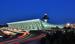
The Dulles International Airport Main Terminal is located in Loudoun and Fairfax counties in Dulles, Virginia, United States. The original structure, 600 feet (180 m) long and 150 feet (46 m) wide, was designed by Eero Saarinen and completed in 1962 as the first terminal at Dulles International Airport. Annexes to the west and east were completed in 1996 as part of a renovation designed by Skidmore, Owings & Merrill, bringing its total length to 1,240 feet (380 m). The terminal is operated by the Metropolitan Washington Airports Authority, which operates Dulles Airport as a whole. The terminal's design is a suspended structure with roof panels of precast concrete suspended between cables which span the width of the building.
The Main Terminal's design includes parallel slanted colonnades on the terminal's north and south facades, interspersed with glass walls. The landside facade to the north is taller than the airside facade to the south; a concave roof supported by cables connects the two facades, descending at the center. A concourse and control tower extend south toward the airport's apron. The interior was originally divided into two levels: an upper story for departing passengers and a lower story for arriving passengers. Saarinen's original design included mobile lounges that ferried passengers directly to planes, reducing the need for long walks or taxiing while increasing the airport's operational flexibility. The modern terminal includes four Z gates, where aircraft could unload passengers directly. In addition, two basements contain security screening facilities and an AeroTrain people-mover station.
The 1950 Washington Airport Act provided funding for Dulles Airport, land for which was acquired in January 1958. Saarinen was selected that May to design the terminal, construction of which began in early 1960. After several delays, the terminal was dedicated on November 17, 1962, along with the rest of the airport. Initially, Dulles Airport saw lower-than-expected usage, but increased patronage prompted the airport's original operator, the Federal Aviation Administration (FAA), to contemplate an expansion in the early 1970s. Hellmuth, Obata & Kassabaum (HOK) built two small annexes to the south in 1978, and further expansions and additional terminals were contemplated in the 1980s following increases in patronage. SOM designed annexes to the west and east, which began construction in October 1993 and were dedicated on September 6, 1996. Additional expansions took place in the 2000s, including the Z gates and the basements.
The structure was widely acclaimed when it was completed, particularly regarding its shape, and Saarinen reportedly considered it his best work. The terminal has also received numerous awards, including the American Institute of Architects' Twenty-five Year Award, and other terminal buildings have been compared with it. Though the Main Terminal was nominated for inclusion on the National Register of Historic Places in 1978, it was never added due to objections from the FAA.


