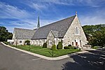
Trumbull Center, Connecticut
Census-designated places in ConnecticutCensus-designated places in Fairfield County, ConnecticutGeography of Fairfield County, ConnecticutNeighborhoods in ConnecticutPopulated places in Fairfield County, Connecticut ... and 2 more
Trumbull, ConnecticutUse mdy dates from July 2023
Trumbull Center is a section or neighborhood of the town of Trumbull in Fairfield County, Connecticut in New England. It is considered the center of the town, and was the seat of town government from 1883 through 1957. The Pequonnock River flows through the center in an easterly direction. The main thoroughfare is Connecticut Route 127 (aka Church Hill Road & White Plains Road). The area was listed as a census-designated place (CDP) prior to the 2020 census.
Excerpt from the Wikipedia article Trumbull Center, Connecticut (License: CC BY-SA 3.0, Authors).Trumbull Center, Connecticut
White Plains Road,
Geographical coordinates (GPS) Address Nearby Places Show on map
Geographical coordinates (GPS)
| Latitude | Longitude |
|---|---|
| N 41.244166666667 ° | E -73.195833333333 ° |
Address
White Plains Road
06611
United States
Open on Google Maps


