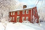
Nichols Farms Historic District

Nichols Farms is a historic area within the town of Trumbull, Connecticut. The Nichols Farms Historic District, which encompasses part of the area, is listed on the National Register of Historic Places. Originally home to the Paugusset people, the Nichols area was colonized by the English during the Great Migration of the 1630s as a part of the coastal settlement of Stratford. The first English settlements followed soon after settlement of the mother-town in 1639.The area was governed by Stratford for eighty six years before a separate village was organized in 1725. Hence, all of Nichols Farms early public records are intermingled with and identified as Stratford records. The early English settlers named Nichols after the family who maintained a large farm in its center. It was first organized as the village of Unity in 1725. The village of Unity (later called North Stratford) continued for seventy-two years before the privileges of a town were granted in 1797.
Excerpt from the Wikipedia article Nichols Farms Historic District (License: CC BY-SA 3.0, Authors, Images).Nichols Farms Historic District
Unity Road,
Geographical coordinates (GPS) Address Nearby Places Show on map
Geographical coordinates (GPS)
| Latitude | Longitude |
|---|---|
| N 41.2425 ° | E -73.164722222222 ° |
Address
Unity Road
Unity Road
06497
Connecticut, United States
Open on Google Maps


