place

Enderby Warren Quarry

Geological Conservation Review sitesSites of Special Scientific Interest in Leicestershire
Enderby Warren Quarry

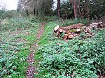
Enderby Warren Quarry is a 1.7-hectare (4.2-acre) geological Site of Special Scientific Interest north of Enderby in Leicestershire. It is a Geological Conservation Review site.This former quarry is described by Natural England as nationally important as it is the only one in Britain where it can be shown that palygorskite clay soil has been formed by the action of groundwater on Triassic and pre-Triassic sediments.The site is private land with no public access.

Excerpt from the Wikipedia article Enderby Warren Quarry (License: CC BY-SA 3.0, Authors, Images).

Enderby Warren Quarry
Harolds Lane,

Geographical coordinates (GPS) Address Nearby Places
placeShow on map

Wikipedia: Enderby Warren QuarryContinue reading on Wikipedia

Geographical coordinates (GPS)

Latitude Longitude
N 52.595 ° E -1.204 °
placeShow on map

Address

Harolds Lane

Harolds Lane
LE19 4DB , Enderby
England, United Kingdom
mapOpen on Google Maps

Enderby Warren Quarry
Share experience

Nearby Places

Thorpe Astley
Thorpe Astley

Thorpe Astley is a suburban settlement on the southwestern edge of the city of Leicester, England. It is part of the civil parish of Braunstone Town, although a small part of the development, around Goodheart Way, extends into Leicester Forest East civil parish. Both Braunstone Town and Leicester Forest East are within the district of Blaby, Leicestershire. This settlement was built on the last area of agricultural land in Braunstone Town. Construction of this development began after approval from the Blaby District Council in 1994. It covers most of a wedge of land between the M1 Motorway on its western side and the A563 ringroad on the east, with the established community of Braunstone West is on its north side. It is neighboured to the south by the Meridian industrial and commercial development. A Community Centre to serve this housing estate was opened in October 2010; this is maintained by Braunstone Town Council. Around the same time a new community group was formed, Your Thorpe Astley, with the aim of furthering the interests of local residents and staging events at the Centre. The name "Thorpe Astley" was derived from the Astley family, who owned land in Braunstone Town from 1334 to 1404. Several roads in the Thorpe Astley estate are named after famous people from history, including the 18th-century political radical Thomas Paine and American paratroop commander General James M. Gavin. The headquarters of General Gavin's U.S. 82nd Airborne Division was stationed at Braunstone Park during 1944.