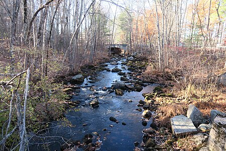
Nissitissit River
Maine placenames of Native American originMassachusetts river stubsMiddlesex County, Massachusetts geography stubsNew Hampshire placenames of Native American originNew Hampshire river stubs ... and 6 more
Rivers of Hillsborough County, New HampshireRivers of MassachusettsRivers of Middlesex County, MassachusettsRivers of New HampshireTributaries of the Merrimack RiverWild and Scenic Rivers of the United States

The Nissitissit River is a 10.5-mile-long (16.9 km) river in southern New Hampshire and northern Massachusetts in the United States. It is a tributary of the Nashua River, itself a tributary of the Merrimack River, which flows to the Gulf of Maine. This river is part of the Nashua River Watershed. The Nissitissit River begins at the outlet of Potanipo Pond in the town of Brookline, New Hampshire. It flows southeast at a very mild gradient, crossing the southwest corner of Hollis, New Hampshire, before entering Massachusetts, where it joins the Nashua River in the town of Pepperell.
Excerpt from the Wikipedia article Nissitissit River (License: CC BY-SA 3.0, Authors, Images).Nissitissit River
Groton Street,
Geographical coordinates (GPS) Address Nearby Places Show on map
Geographical coordinates (GPS)
| Latitude | Longitude |
|---|---|
| N 42.671666666667 ° | E -71.564722222222 ° |
Address
The Land Between The Rivers
Groton Street
01363
Massachusetts, United States
Open on Google Maps


