place

Beachmont station

1954 establishments in MassachusettsBlue Line (MBTA) stationsFormer Boston, Revere Beach and Lynn Railroad stationsRailway stations in Suffolk County, MassachusettsRailway stations in the United States opened in 1954
Revere, Massachusetts
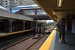
Outbound train at Beachmont station, August 2018

Beachmont is an elevated rapid transit station in Revere, Massachusetts. It serves the MBTA Blue Line, and is located above Winthrop Avenue in the Beachmont neighborhood. Beachmont station is fully accessible, with elevators from the lobby to the platforms.

Excerpt from the Wikipedia article Beachmont station (License: CC BY-SA 3.0, Authors, Images).

Beachmont station
Bennington Street, Revere

Geographical coordinates (GPS) Address Nearby Places
placeShow on map

Wikipedia: Beachmont stationContinue reading on Wikipedia

Geographical coordinates (GPS)

Latitude Longitude
N 42.3975 ° E -70.9922 °
placeShow on map

Address

Bennington Street 1;5
02152 Revere
Massachusetts, United States
mapOpen on Google Maps

Outbound train at Beachmont station, August 2018
Share experience

Nearby Places

Suffolk Downs station

Suffolk Downs station is a rapid transit station on the Massachusetts Bay Transportation Authority (MBTA) Blue Line, located on the east side of Orient Heights in East Boston, Massachusetts, United States. It is named for the now-defunct Suffolk Downs racetrack, located just to the north. Suffolk Downs station has two side platforms, with a footbridge structure of brick, concrete, and steel connecting them. The station is accessible. With just 521 daily boardings in FY 2019, Suffolk Downs is the least-used fare-controlled station on the MBTA subway system. Two previous stations at the site were operated by the Boston, Revere Beach and Lynn Railroad, which opened through East Boston in 1875. The railroad opened Waldemar station in 1894 to serve a nearby development; it was soon renamed Belle Isle. The station closed in the 1920s, but a new station named Suffolk Downs station opened on the site in 1935 to serve the new racetrack. Service on the line ended in 1940. Electric streetcar service on a parallel line operated from 1893 to 1952; a spur line directly to the racetrack was operated from 1935 to 1952. The Metropolitan Transportation Authority (MTA) purchased the abandoned right-of-way in 1941 to extend the East Boston Tunnel rapid transit line. The MTA opened its Suffolk Downs station with a single platform in 1952; it was expanded with a second platform in 1954 as part of the second phase of the Revere Extension. After a 1976 fire, only the inbound platform remained open until a 1982–1984 renovation. The station was renovated further in 1994–95, and further improvements are planned as part of a redevelopment of the racetrack site.

Rumney Marsh Burying Ground

The Rumney Marsh Burying Ground is a historic cemetery on Butler Street between Elm and Bixby Streets in Revere, Massachusetts. It was added to the National Register of Historic Places in 2004. It was the first burying ground of an area that now encompasses Revere as well as neighboring Chelsea and Winthrop.The land was originally owned by Samuel Cole. In 1654 William Hasey purchased it; his descendants sold it to Joshua Cheever, Esq. in 1740. Cheever and the town of Chelsea (of which Revere was still part) agreed on March 7, 1743 that the land would be a burying place and he deeded it to the town on December 8, 1751.Prior to the establishment of this burying ground, people who lived in the area were buried in Boston's Copp's Hill Burying Ground. After a smallpox epidemic swept the city in 1690, Boston officials ordered that its victims north of the Charles River be buried "on that side of the Water". Some victims of this epidemic may have been the first burials at Rumney Marsh. The first documented burial was that of Mary Smith, wife of John Smith, in 1693. The last burial was in 1929.The cemetery is notable for containing the graves of sixteen Black individuals, some free and some enslaved, whose burials are documented in part by an 1897 map of the site. Two plaques stand along the Northern wall of the cemetery providing the names, dates of death, and approximate ages of these individuals, as well as some of the names of their enslavers. Most are buried along the Northern wall. However, according to a 1938 book called "The History of Revere" by Benjamin Shurtleff, three — Job Worrow (a veteran of the Revolutionary War serving under Captain Samuel Sprague, who is also buried in the Rumney Marsh Burying Ground), Betty Worrow, and Fanny Fairweather — are buried in the Southeast corner. Although none of these individuals' graves are marked, Fanny Fairweather is reported by Shurtleff to have had a monument with the inscription "Fanny Fairweather, died 1845, age 80, a native of Africa."Since many of the burials were in the 18th century, the cemetery is exemplary of funerary art during the colonial period. For example, many of the slate gravestones feature a skull and wings motif. Two gravestones have been specifically identified as the work of carver Joseph Lamson (1658-1722); that of Mary Cutler (died 1703), and that of John Winthrop's son Deane Winthrop (died 1703/4). Work by stone carvers Robert Fowle and Richard Adams can also be found among the graves.People buried in the cemetery include: Deane Winthrop, son of John Winthrop, governor of the Massachusetts Bay Colony. Deane Winthrop's House, also on the National Register, is nearby in Winthrop. Phillips Payson, the fighting pastor, hero of the Battle of Lexington Sixteen enslaved and free Black people Veterans of the Colonial, Revolutionary, 1812, and Civil Wars.