place

Thomastown, Rhondda Cynon Taf

AC with 0 elementsVillages in Rhondda Cynon TafWales geography stubs
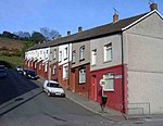
Nant Melyn Terrace, Thomastown geograph.org.uk 415011

Thomastown is a village and district of the large community of Tonyrefail, within Rhondda Cynon Taf, South Wales. It is located to the south of Tonyrefail within the 'Tonyrefail West' electoral ward, and falls within the Ely Valley along the A4119. Thomastown is also a community ward for elections to Tonyrefail & District Community Council.

Excerpt from the Wikipedia article Thomastown, Rhondda Cynon Taf (License: CC BY-SA 3.0, Authors, Images).

Thomastown, Rhondda Cynon Taf
Oakwood Drive,

Geographical coordinates (GPS) Address Nearby Places
placeShow on map

Wikipedia: Thomastown, Rhondda Cynon TafContinue reading on Wikipedia

Geographical coordinates (GPS)

Latitude Longitude
N 51.57509 ° E -3.43762 °
placeShow on map

Address

Oakwood Drive

Oakwood Drive
CF39 8EG , Tonyrefail
Wales, United Kingdom
mapOpen on Google Maps

Nant Melyn Terrace, Thomastown geograph.org.uk 415011
Share experience

Nearby Places

Penychen

Penychen was a possible minor kingdom of early medieval Wales and later a cantref of the Kingdom of Morgannwg. Penychen was one of three cantrefi that made up the kingdom of Glywysing, lying between the rivers Taff and Thaw, the other two being Gwynllwg and Gorfynydd. According to tradition, these cantrefi were created on the death of Glywys (c.480 AD), the first king of Glywysing, when the kingdom was divided between his three sons: Pawl, Gwynllyw and Mechwyn. But our knowledge of the early history of the kingdom is very uncertain, being mainly sourced from medieval documents and traditional pedigrees. Pawl was the ruler of Penychen and on his death (c.540 AD) passed the cantref on to his nephew.Pawl's brother Gwynllyw was the ruler of Gwynllwg and upon his death it is said that the cantref passed to his son Cadoc (Cadwg), also known as St. Cadoc. Cadoc would later take control of Penychen, but when he was killed by the Saxons he had no heirs, and both cantrefi fell under the control of Meureg of Gwent and were absorbed into his kingdom. After the Norman conquest of South Wales, the southern parts of Penychen, on the Bristol Channel, came under the direct rule of the Norman Marcher Lords and their descendants, but the rest (the commotes of Rhondda Valley and Miskin) remained under the rule of local Welsh lords, who paid homage to the powerful Norman lords but still retained a degree of independence, which they were very ready to defend. In the Middle Ages Penychen contained two important ecclesiastical centres: the episcopal seat of Llandaf, and Llancarfan, a clas connected to the early author Caradoc of Llancarfan.