place

RAF Scampton

Airports in EnglandMilitary units and formations established in 1936Pages containing London Gazette template with parameter supp set to yPortal templates with redlinked portalsRoyal Air Force stations in Lincolnshire
Royal Air Force stations of World War II in the United KingdomRoyal Flying Corps airfieldsUse British English from May 2013World War I airfieldsWorld War I sites in England
Red Arrows geograph.org.uk 4275330

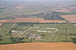
Royal Air Force Scampton or RAF Scampton (formerly IATA: SQZ, ICAO: EGXP) is a former Royal Air Force station located adjacent to the A15 road near to the village of Scampton, Lincolnshire, and 6 miles (9.7 km) north-west of the city of Lincoln, England.RAF Scampton stood on the site of a First World War Royal Flying Corps landing field, which had been called Brattleby. The station was closed and returned to agriculture following the First World War, and reactivated in the 1930s. It has provided an airfield for fighters in the First World War, bombers during the Second World War and V-force Avro Vulcans during the Cold War. The station was temporarily closed in 1996, but subsequently re-opened to provide a home for the RAF Aerobatic Team the Red Arrows, and to private companies, temporarily, such as Hawker Hunter Aviation, for the maintenance and storage of aircraft.In July 2018, the Ministry of Defence announced that Scampton would close and be sold, with all units relocated elsewhere. The station closed on 31 March 2023.

Excerpt from the Wikipedia article RAF Scampton (License: CC BY-SA 3.0, Authors, Images).

RAF Scampton
Middle Street, West Lindsey

Geographical coordinates (GPS) Address Nearby Places
placeShow on map

Wikipedia: RAF ScamptonContinue reading on Wikipedia

Geographical coordinates (GPS)

Latitude Longitude
N 53.307777777778 ° E -0.55083333333333 °
placeShow on map

Address

Middle Street
LN1 2WE West Lindsey
England, United Kingdom
mapOpen on Google Maps

Red Arrows geograph.org.uk 4275330
Share experience

Nearby Places

Grange de Lings
Grange de Lings

Grange de Lings is a civil parish in the West Lindsey district of Lincolnshire, England. It is situated 3 miles (5 km) north from the city centre of the county town of Lincoln. Grange de Lings is often quoted as the address for the Lincolnshire Showground, just off the west of the A15, but the parish actually lies entirely east of the A15, and the Lincolnshire Showground is in the parish of North Carlton. The parish is sometimes hyphenated as Grange-de-Lings. The north-western corner of the parish is at the A1500 junction with the A15, at a roundabout. The boundary follows Horncastle Lane eastwards where it neighbours Welton, to the north. At Dunholme, it follows southwards across the old runways of RAF Dunholme Lodge, of which the western end was in Grange de Lings. It briefly meets Scothern, and a small section of the parish extends between Scothern and Nettleham, to meet the A46, which it follows for around 200 metres. The boundary with Nettleham passes westwards, then south-west across Hall Lane, then meets Riseholme, where it follows a line due west to the A15 (Ermine Street), meeting South Carlton just south of the pylons across the A15. The western boundary of the parish is the A15, and just north of Watering Dyke Houses, it meets North Carlton at the perimeter fence of the Lincolnshire Showground (wholly outside the parish). There is an oil well in the north of the parish, next to the boundary with Welton, part of the East Midlands Oil Province. The parish has no parish church, but is part of the St Mary's church in the Riseholme with Grange de Lings parish, looked after by Nettleham parish, where the vicar is based. Grange-de-Lings in this respect is known as an extra-parochial district. For statistical and administrative purposes, it is joined with Riseholme (similar to the religious parish)