place

Godmersham

Civil parishes in Ashford, KentVillages in KentVillages in the Borough of Ashford
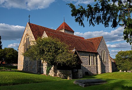
St Lawrence Godmersham 2

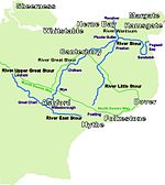
Godmersham is a village and civil parish in the Ashford District of Kent, England. The village straddles the Great Stour river where it cuts through the North Downs and its land is approximately one third woodland, all in the far east and west on the escarpment of the North Downs. It is six miles north-east of Ashford on the A28 road midway between Ashford and Canterbury in an Area of Outstanding Natural Beauty with the North Downs Way and Pilgrims' Way traversing the parish. The village is divided in two by the floodplain of the Stour. The parish civil includes Godmersham village itself, and Bilting. It shares many of its activities with the neighbouring parish of Crundale, a smaller parish to the east.

Excerpt from the Wikipedia article Godmersham (License: CC BY-SA 3.0, Authors, Images).

Godmersham
Canterbury Road,

Geographical coordinates (GPS) Address Nearby Places
placeShow on map

Wikipedia: GodmershamContinue reading on Wikipedia

Geographical coordinates (GPS)

Latitude Longitude
N 51.218 ° E 0.9571 °
placeShow on map

Address

Canterbury Road

Canterbury Road
CT4 7DR
England, United Kingdom
mapOpen on Google Maps

St Lawrence Godmersham 2
Share experience

Nearby Places

Julliberrie's Grave
Julliberrie's Grave

Julliberrie's Grave, also known as The Giant's Grave or The Grave, is an unchambered long barrow located near to the village of Chilham in the south-eastern English county of Kent. Probably constructed in the fourth millennium BCE, during Britain's Early Neolithic period, today it survives only in a state of ruin. Archaeologists have established that the monument was built by pastoralist communities shortly after the introduction of agriculture to Britain from continental Europe. Although representing part of an architectural tradition of long barrow building that was widespread across Neolithic Europe, Julliberrie's Grave belongs to a localised regional variant of barrows produced in the vicinity of the River Stour. Of these, it lies on the eastern side of the river, alongside the Shrub's Wood Long Barrow, while the third known example in this barrow group, Jacket's Field Long Barrow, is located on the western side. Julliberrie's Grave is 44 metres (144 ft) long, 2 metres (6 ft 7 in) high, and 15 metres (49 ft) at its widest. It was originally larger, with the northern end having been destroyed. Unlike many other long barrows, no evidence for any Early Neolithic human remains have been found at the site; it is possible that its builders never placed human remains within it, or that such burials were included in the barrow's (since lost) northern end. A broken polished stone axe was included in the centre of the monument, which archaeologists believe was likely placed there as part of a ritual act of deposition. A rectangular pit was dug into the western side of the barrow shortly after its completion, likely containing a ritual deposit of organic material, before being refilled. In the Iron Age, a hearth was established in the ditch circling the barrow; in the Romano-British period, human remains and a coin hoard were buried around its perimeter. Ensuing millennia witnessed local folklore grow up around the site, associating it with the burial of either a giant or an army and their horses. The ruin attracted the interest of antiquarians in the 17th century, although was heavily damaged by chalk quarrying around the 18th. During the 18th and 19th century, antiquarians dug into the barrow at least twice, while cautious archaeological excavation took place in the 1930s. A Scheduled Ancient Monument, it is accessible to visitors all year around.

Wye College
Wye College

The College of St Gregory and St Martin at Wye, commonly known as Wye College, was an education and research institution in the village of Wye, Kent. In 1447, Cardinal John Kempe founded his chantry there which also educated local children.: 18  As of 2020, it still includes a rare, complete example of medieval chantry college buildings.: 5  After abolition in 1545, parts of the premises were variously occupied as mansion, grammar school, charity school, infant school and national school, before purchase by Kent and Surrey County Councils to provide men's technical education.: 30, 36, 48, 49, 60  For over a hundred years Wye became the school, then college, of London University most concerned with rural subjects, including agricultural sciences; business management; agriculture; horticulture, and agricultural economics. Chemist and Actonian Prize winner, Louis Wain: 441  developed synthetic auxin selective herbicides 2,4-DB, MCPB and Bromoxynil at Wye in the 1950s: 448–450  alongside his other research into insecticides, plant growth regulators and fungicides.: 451–453  Wain's colleague Gerald Wibberley championed alternative priorities for the college with an early emphasis on land use and the environment.: 454 Following World War II and a 1947 merger with Swanley Horticultural College for women,: 444  Wye transformed itself from small agricultural college, providing local practical instruction, to university: 488  for a rapidly increasing number of national and international students.: 79  Successive phases of expansion developed the college's campus along Olantigh Road,: 6  Withersdane Hall the country's first post-war, purpose built university hall of residence,: 488  and accumulated an estate of nearly 1,000 acres (400 ha). However, after a difficult 2000 merger with Imperial College and controversial 2005 attempt to build 4,000 houses on its farmland, Imperial College at Wye closed in 2009.: 30, 45, 46, 50 As of 2010, the pioneering postgraduate distance learning programme created at Wye College continued within SOAS.: 49  Many of the college buildings have been redeveloped, though some are retained for community use or occasional public access.