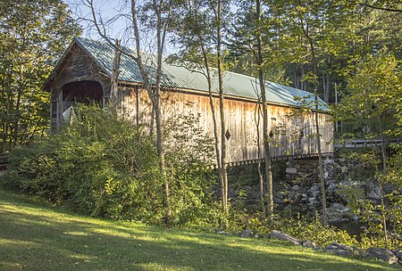
Hall Covered Bridge
1867 establishments in Vermont1980 disestablishments in Vermont1982 establishments in VermontBridges completed in 1867Bridges completed in 1982 ... and 9 more
Buildings and structures demolished in 1980Buildings and structures in Rockingham, VermontCovered bridges in Windham County, VermontCovered bridges on the National Register of Historic Places in VermontHistoric American Engineering Record in VermontLattice truss bridges in the United StatesNational Register of Historic Places in Windham County, VermontRoad bridges on the National Register of Historic Places in VermontWooden bridges in Vermont

The Hall Covered Bridge, located in southern Rockingham, Vermont, carries Hall Bridge Road across the Saxtons River, just north of its junction with Vermont Route 121. It is a Town lattice truss bridge, built in 1982 as a replica of a circa-1867 bridge that was destroyed by an overweight truck in 1980. The bridge was listed on the National Register of Historic Places in 1973.
Excerpt from the Wikipedia article Hall Covered Bridge (License: CC BY-SA 3.0, Authors, Images).Hall Covered Bridge
Saxtons River Road, Rockingham
Geographical coordinates (GPS) Address Nearby Places Show on map
Geographical coordinates (GPS)
| Latitude | Longitude |
|---|---|
| N 43.136666666667 ° | E -72.487777777778 ° |
Address
Saxtons River Road 500
05101 Rockingham
Vermont, United States
Open on Google Maps


