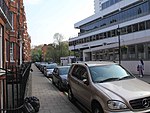
Paddington Street
London road stubsPaddingtonStreets in the City of WestminsterUse British English from December 2016

Paddington Street is a street in the City of Westminster in London that runs from the junction of Crawford Street and Baker Street in the east to Marylebone High Street in the west. Sherlock Mews, Chiltern Street, Luxborough Street, and Nottingham Place join Paddington Street on its north side. On the south side, Kenrick Place, Chiltern Street, and Ashland Place adjoin Paddington Street. The two open spaces of Paddington Street Gardens are situated on either side of the road. The Hellenic Centre is located at 16–18 Paddington Street.
Excerpt from the Wikipedia article Paddington Street (License: CC BY-SA 3.0, Authors, Images).Paddington Street
Ashland Place, London Marylebone
Geographical coordinates (GPS) Address Nearby Places Show on map
Geographical coordinates (GPS)
| Latitude | Longitude |
|---|---|
| N 51.520644444444 ° | E -0.15359444444444 ° |
Address
Ashland Place
Ashland Place
W1U 4AQ London, Marylebone
England, United Kingdom
Open on Google Maps


