place

Double School House Number 6

Buildings and structures in Queen Anne's County, MarylandMaryland school stubsSchool buildings completed in 1834Use American English from December 2015Use mdy dates from December 2015
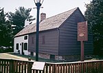
Double schoolhouse Number 6, front elevation

Double School House Number 6 is a historic school house located in Queenstown, in Queen Anne's County, Maryland, United States. The double school house was built after a large fire in Queenstown. The property was purchased by school trustees James Masey and his wife, in 1834. As was common at the time, the building featured two separate entrances for boys and girls. In 1874, a larger school house was built on Del Rhodes Avenue, to serve the community of 250 residents. The school was moved to a new alignment and converted to a private residence in 1884.

Excerpt from the Wikipedia article Double School House Number 6 (License: CC BY-SA 3.0, Authors, Images).

Double School House Number 6
Main Street,

Geographical coordinates (GPS) Address Nearby Places
placeShow on map

Wikipedia: Double School House Number 6Continue reading on Wikipedia

Geographical coordinates (GPS)

Latitude Longitude
N 38.990916666667 ° E -76.155833333333 °
placeShow on map

Address

EMS Station 300

Main Street 7114
21836
Maryland, United States
mapOpen on Google Maps

Double schoolhouse Number 6, front elevation
Share experience

Nearby Places

Chester River
Chester River

The Chester River is a major tributary of the Chesapeake Bay on the Delmarva Peninsula. It is about 43 miles (69 km) long, and its watershed encompasses 368 sq mi (950 km2), which includes 295 sq mi (760 km2) of land. Thus the total watershed area is 20% water. It forms the border between Kent County and Queen Anne's County, Maryland, with its headwaters extending into New Castle County and Kent County, Delaware. Chestertown, the seat of Maryland's Kent County, is located on its north shore. It is located south of the Sassafras River and north of Eastern Bay, and is connected with Eastern Bay through Kent Narrows. The Chester River begins at Millington, Maryland, where Cypress Branch and Andover Branch join together. It ends at the Chesapeake Bay in a very wide mouth between Love Point on Kent Island, and Swan Point, near Gratitude, Maryland. Cypress Branch rises in southwestern New Castle County, Delaware, and Andover Branch, with its tributary, Sewell Branch, rises in northwestern Kent County, Delaware. Millington is the head of navigation. Sewell Branch and Andover Branch join in a private impoundage of approximately 30 acres (120,000 m2) about two miles (3 km) above joining with Cypress Branch and then becoming the Chester River. Its main tributaries are Langford Creek and Morgan Creek on the north side and the Corsica River and Southeast Creek on the south side. There are also several small creeks on the northern shore, including Church Creek, Grays Inn Creek, Shippen Creek, Jarrett Creek, Browns Creek, Broad Creek, Dam Creek, Morgan Creek, Radcliffe Creek, and Mills Branch. On the southern shore the small creeks include Queenstown Creek, Tilghman Creek, Reed Creek, Grove Creek, Hambleton Creek, Rosin Creek, Foreman Branch and Unicorn Branch.

Wye River (Maryland)

The Wye River is a 16.3-mile-long (26.2 km) tributary of the Chesapeake Bay, on the Eastern Shore of Maryland. It was named by the Lloyd family, Edward Lloyd (delegate), and Edward Lloyd (Governor of Maryland), after the River Wye in the United Kingdom. It falls within Queen Anne's County and Talbot County, and joins the Miles River near its mouth to the Eastern Bay. The river is popular with recreational boaters because of its secluded anchorages, fishing, crabbing and proximity to the tourist attractions of St. Michaels, Maryland. Like many rivers on the Chesapeake Bay, the Wye is largely tidal. The river's features include the 2,800-acre (11 km2) Wye Island, most of which is part of the Wye Island Natural Resources Management Area, managed by the Maryland Department of Natural Resources State Forest and Park Service. William Paca, the third governor of Maryland and a signatory to the Declaration of Independence, once owned the island. The nearby Aspen Institute Wye River Conference Centers (sections of which were formerly known as the "Wye River plantation") hosted the 1998 Mideast Peace talks attended by Israeli Prime Minister Benjamin Netanyahu and Palestinian Authority Chairman Yasser Arafat, and hosted by US President Bill Clinton that culminated in the Wye River Memorandum. The watershed also includes the Wye Research and Education Center, operated by the University of Maryland College of Agriculture and Natural Resources, Maryland Agricultural Experiment Station (MAES). They conduct agricultural research and education, in cooperation with the nearby Aspen Institute Wye River Conference Centers. Elián González and his father stayed at the Wye River Plantation briefly in 2000.Water quality is threatened by development.