place

Cotes, Leicestershire

Borough of CharnwoodCivil parishes in LeicestershireHamlets in LeicestershireLeicestershire geography stubsUse British English from July 2015
Cotes1
Cotes1

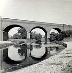
Cotes is a hamlet and very small civil parish near the town of Loughborough in Leicestershire, England. Cotes has a population of about 50. At the 2011 census the population remained less than 100 and was included in the civil parish of Burton on the Wolds. The name 'Cotes' derives from the Old English cot meaning 'cottages'.It lies on the River Soar, and Cotes Bridge provides the main bridging point in that area. The A60 Trunk Road goes over Cotes Bridge on its way out of Loughborough towards Nottingham. The B676, the only other significant nearby road, begins at the A60 just to the east of Cotes Bridge and goes off towards the village of Burton on the Wolds. There was a minor battle at Cotes Bridge on 18 March 1644 during the First English Civil War, when Royalist forces captured the bridge on their way to relieve Newark. The medieval village of Cotes itself was abandoned around 1690, possibly because of plague, although most commentators suggest the impact of the Inclosure Acts is a more likely explanation.The former Member of Parliament for the local Loughborough constituency from 2010-2019, Nicky Morgan, chose to include the name of the area as part of her title upon elevation to the House of Lords as Baroness Morgan of Cotes.

Excerpt from the Wikipedia article Cotes, Leicestershire (License: CC BY-SA 3.0, Authors, Images).

Cotes, Leicestershire
Loughborough Road, Charnwood Cotes

Geographical coordinates (GPS) Address Nearby Places
placeShow on map

Wikipedia: Cotes, LeicestershireContinue reading on Wikipedia

Geographical coordinates (GPS)

Latitude Longitude
N 52.782083333333 ° E -1.1781944444444 °
placeShow on map

Address

Loughborough Road

Loughborough Road
LE12 5TG Charnwood, Cotes
England, United Kingdom
mapOpen on Google Maps

Cotes1
Cotes1
Share experience

Nearby Places

Loughborough Gap
Loughborough Gap

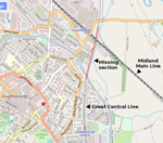
The Loughborough Gap is a 500-metre-long (0.3 mi) missing section of the Great Central Railway to the north-east of Loughborough, England. The gap was created by the removal of embankments and bridges during the 1980s and the restoration project has been branded Bridge to the Future and Bridging the Gap. From south-to-north the route crosses the Grand Union Canal, Railway Terrace road, a Factory car park, four-track Midland Main Line at Loughborough railway station and the A60 road. The Hermitage Brook watercourse runs parallel. During the 2010s work began to restore the link in order to join the northern and southern sections of two heritage railways back together giving a total Great Central Railway (heritage railway) line length of 18 miles (29 km). As of 2016, planning permission was granted for the first major component: a replacement 30-metre single-span bridge over the Midland Main Line. An additional station called Loughborough High Level will be built to connect with Loughborough (Midland) station on the Midland Main Line. As of May 2016, the bridge was intended to be owned by Charnwood Borough Council and then leased back to the Great Central Railway for one hundred years in exchange for maintenance costs. Work commenced in April 2017, with the main bridge beams being installed in September of that year. The bridge is expected to be completed in 2019.The replacement bridge was completed ahead of schedule in August 2018. However due to slight encroachment on the original trackbed, the bridge is slightly askew from the original alignment. Refurbishment has also been conducted on the canal bridge just beyond the existing train shed. Future work will see the embankment reinstated and the current train shed demolished and replaced by one close by as the shed occupies the main line alignment. In addition signalling will need be connected and updated to match the other preserved line.