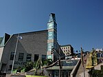
place

Lévis station

Buildings and structures in Lévis, QuebecCanadian National Railway stations in QuebecQuebec City stubsQuebec railway station stubsTransport in Lévis, Quebec
Via Rail stations in Quebec
Gare de l'Intercolonial à Lévis

Lévis station (also known as Gare fluviale de Lévis and as Gare de l'Intercolonial) is a ferry terminal and former railway station in Lévis, Quebec, Canada at 5995, rue Saint-Laurent. It is also served by city buses operated by the Société de transport de Lévis. The Société des traversiers du Québec operates ferry service between this terminal and downtown Quebec City.The station was built in 1864 as a meeting room for Lévis' city council. In 1884, it was purchased the Intercolonial Railway for use as a station, and was later used by Canadian National and Via Rail trains until CN abandoned its railway line in downtown Lévis. The final Via Rail from the station operated October 24, 1998. Today, the building serves as a ferry terminal, and also houses a bicycle rental facility and tourist information centre.The former railway right-of-way is now a bicycle trail.

Excerpt from the Wikipedia article Lévis station (License: CC BY-SA 3.0, Authors, Images).

Lévis station
Rue Laurier, Lévis Lévis (quartier) (Desjardins)

Geographical coordinates (GPS) Address External links Nearby Places
placeShow on map

Wikipedia: Lévis stationContinue reading on Wikipedia

Geographical coordinates (GPS)

Latitude Longitude
N 46.810319444444 ° E -71.1871 °
placeShow on map

Address

Ancienne gare fluviale Québec-Lévis

Rue Laurier
G6V 3N9 Lévis, Lévis (quartier) (Desjardins)
Quebec, Canada
mapOpen on Google Maps

linkWikiData (Q18619250)
linkOpenStreetMap (168781382)

Gare de l'Intercolonial à Lévis
Share experience

Nearby Places

Battle of Quebec (1775)

The Battle of Quebec (French: Bataille de Québec) was fought on December 31, 1775, between American Continental Army forces and the British defenders of Quebec City early in the American Revolutionary War. The battle was the first major defeat of the war for the Americans, and it came with heavy losses. General Richard Montgomery was killed, Benedict Arnold was wounded, and Daniel Morgan and more than 400 men were taken prisoner. The city's garrison, a motley assortment of regular troops and militia led by Quebec's provincial governor, General Guy Carleton, suffered a small number of casualties. Montgomery's army had captured Montreal on November 13, and early in December they became one force that was led by Arnold, whose men had made an arduous trek through the wilderness of northern New England. Governor Carleton had escaped from Montreal to Quebec, the Americans' next objective, and last-minute reinforcements arrived to bolster the city's limited defenses before the attacking force's arrival. Concerned that expiring enlistments would reduce his force, Montgomery made the end-of-year attack in a blinding snowstorm to conceal his army's movements. The plan was for separate forces led by Montgomery and Arnold to converge in the lower city before scaling the walls protecting the upper city. Montgomery's force turned back after he was killed by cannon fire early in the battle, but Arnold's force penetrated further into the lower city. Arnold was injured early in the attack, and Morgan led the assault in his place before he became trapped in the lower city and was forced to surrender. Arnold and the Americans maintained an ineffectual blockade of the city until spring, when British reinforcements arrived.

Maritime Rescue Sub-Centre Quebec

Maritime Rescue Sub-Centre Quebec (MRSC Quebec) is a Canadian Maritime Rescue Sub-Centre that coordinates search and rescue operations in the following waters: the St. Lawrence River within the province of Quebec the northern and western waters of the Gulf of St. Lawrence within the province of Quebec the navigable estuary portion of the Saguenay River the Richelieu River within the province of Quebec the southern portion of the Ottawa River downstream from the Carillon Generating Station Operated by the Canadian Coast Guard (CCG), MRSC Quebec has an area of responsibility that straddles the search and rescue regions (SRR) of Joint Rescue Coordination Centre Halifax (JRCC Halifax) in the east and Joint Rescue Coordination Centre Trenton (JRCC Trenton) in the west. In Canada, MRSCs are established to enhance maritime SAR co-ordination through improved communications and local knowledge. MRSCs thus speed up the initiation of appropriate action, and allow a timely response to SAR incidents within their Search and Rescue Sub-Region (SRS). MRSC Québec is also the sole bilingual Search and Rescue Centre in Canada and one of the two Rescue centres in North America using French language as the main working language (Fort-de-France, in Martinique being the second one). MRSC Québec is responsible for tasking appropriate maritime SAR resources in order to resolve an incident. This is most often the dedicated SAR vessels of the Canadian Coast Guard, however, they may also initiate a request for other resources like volunteers from the Canadian Coast Guard Auxiliary, Royal Canadian Air Force primary or secondary SAR aircraft, Royal Canadian Navy warships, Sûreté du Québec small craft, and municipal police small craft as required. Any SAR operation in response to an aircraft incident remains the responsibility of JRCC Halifax or JRCC Trenton and MRSC Québec may assist the JRCC in tasking and coordinating any maritime resources and provide local expertise and assistance to the JRCC. MRSC Quebec has operated out of Canadian Coast Guard Base Quebec (CCG Base Quebec) since 1977 and handles an average of 1500 incidents each year.

Rue du Petit-Champlain

Rue du Petit-Champlain (English: Little Champlain Street) is a street in the Canadian city of Quebec City, Quebec. It is located in the Petit Champlain commercial district, at the foot of Cap Diamant, and contains many boutique shops. Quartier du Petit Champlain is claimed to be the oldest commercial district in North America. It is named for Samuel de Champlain, who founded Quebec City in 1608.Rue du Petit-Champlain is around 0.16 miles (0.26 km) long, and runs from its convergence with Rue Sous-le-Fort in the north to Boulevard Champlain in the south. A popular viewing point of the street, the Breakneck Stairs (or Breakneck Steps), are located at the northern end of the street. Just beyond the steps is the lower entrance of the Funiculaire du Vieux-Québec, an electric cableway established in 1879. It takes passengers up and down Cap Diamant to and from Dufferin Terrace, beside the Château Frontenac. It climbs at a 45-degree angle, covering a total distance of 64 metres (210 ft).Around halfway along the street, on its western side, is Parc Félix-Leclerc. The western side of the street contains frontages of buildings, in the shadow of Cap Diamant to their rears, whereas the rears of the buildings facing Boulevard Champlain occupy the eastern side. A fresco painted on the side of the building at number 102 is a trompe-l'œil measuring 100m2 (900 ft2). It represents the history of the district, the bombardments of 1759, the landslides, and the fires which have occurred in the district.