place

Cap Diamant

Headlands of QuebecLandforms of Capitale-NationaleLandforms of Quebec CityQuebec City stubsQuebec geography stubs
Saint Lawrence River

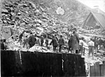
Cap Diamant (English: Cape Diamond) is a cape on an edge of the Promontory of Quebec and on which Quebec City is located, formed by the confluence of a bend in the St. Lawrence River to the south and east, and the much smaller Saint-Charles River to the north. Jacques Cartier, the French explorer who found glittering stones in the high cliff, thought the stones contained diamonds. After he brought samples of these stones to France in 1542, experts concluded that these "diamonds" were actually quartz, hence the proverb "Faux comme un diamant du Canada" ("as fake (or as false) as a Canadian diamond").In 1759, the troops of British General James Wolfe climbed Cap Diamant toward the Plains of Abraham to conquer Quebec. In 1889 the Quebec rockslide fell from Cap Diamant.

Excerpt from the Wikipedia article Cap Diamant (License: CC BY-SA 3.0, Authors).

Cap Diamant
Boulevard Champlain, Quebec

Geographical coordinates (GPS) Address Nearby Places
placeShow on map

Wikipedia: Cap DiamantContinue reading on Wikipedia

Geographical coordinates (GPS)

Latitude Longitude
N 46.809166666667 ° E -71.201666666667 °
placeShow on map

Address

Garde côtière canadienne

Boulevard Champlain 101
G1K 4H7 Quebec (La Cité-Limoilou)
Quebec, Canada
mapOpen on Google Maps

Share experience

Nearby Places

Maritime Rescue Sub-Centre Quebec

Maritime Rescue Sub-Centre Quebec (MRSC Quebec) is a Canadian Maritime Rescue Sub-Centre that coordinates search and rescue operations in the following waters: the St. Lawrence River within the province of Quebec the northern and western waters of the Gulf of St. Lawrence within the province of Quebec the navigable estuary portion of the Saguenay River the Richelieu River within the province of Quebec the southern portion of the Ottawa River downstream from the Carillon Generating Station Operated by the Canadian Coast Guard (CCG), MRSC Quebec has an area of responsibility that straddles the search and rescue regions (SRR) of Joint Rescue Coordination Centre Halifax (JRCC Halifax) in the east and Joint Rescue Coordination Centre Trenton (JRCC Trenton) in the west. In Canada, MRSCs are established to enhance maritime SAR co-ordination through improved communications and local knowledge. MRSCs thus speed up the initiation of appropriate action, and allow a timely response to SAR incidents within their Search and Rescue Sub-Region (SRS). MRSC Québec is also the sole bilingual Search and Rescue Centre in Canada and one of the two Rescue centres in North America using French language as the main working language (Fort-de-France, in Martinique being the second one). MRSC Québec is responsible for tasking appropriate maritime SAR resources in order to resolve an incident. This is most often the dedicated SAR vessels of the Canadian Coast Guard, however, they may also initiate a request for other resources like volunteers from the Canadian Coast Guard Auxiliary, Royal Canadian Air Force primary or secondary SAR aircraft, Royal Canadian Navy warships, Sûreté du Québec small craft, and municipal police small craft as required. Any SAR operation in response to an aircraft incident remains the responsibility of JRCC Halifax or JRCC Trenton and MRSC Québec may assist the JRCC in tasking and coordinating any maritime resources and provide local expertise and assistance to the JRCC. MRSC Quebec has operated out of Canadian Coast Guard Base Quebec (CCG Base Quebec) since 1977 and handles an average of 1500 incidents each year.

Rue du Petit-Champlain

Rue du Petit-Champlain (English: Little Champlain Street) is a street in the Canadian city of Quebec City, Quebec. It is located in the Petit Champlain commercial district, at the foot of Cap Diamant, and contains many boutique shops. Quartier du Petit Champlain is claimed to be the oldest commercial district in North America. It is named for Samuel de Champlain, who founded Quebec City in 1608.Rue du Petit-Champlain is around 0.16 miles (0.26 km) long, and runs from its convergence with Rue Sous-le-Fort in the north to Boulevard Champlain in the south. A popular viewing point of the street, the Breakneck Stairs (or Breakneck Steps), are located at the northern end of the street. Just beyond the steps is the lower entrance of the Funiculaire du Vieux-Québec, an electric cableway established in 1879. It takes passengers up and down Cap Diamant to and from Dufferin Terrace, beside the Château Frontenac. It climbs at a 45-degree angle, covering a total distance of 64 metres (210 ft).Around halfway along the street, on its western side, is Parc Félix-Leclerc. The western side of the street contains frontages of buildings, in the shadow of Cap Diamant to their rears, whereas the rears of the buildings facing Boulevard Champlain occupy the eastern side. A fresco painted on the side of the building at number 102 is a trompe-l'œil measuring 100m2 (900 ft2). It represents the history of the district, the bombardments of 1759, the landslides, and the fires which have occurred in the district.