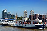
Chelsea Harbour
AC with 0 elementsAreas of LondonDefunct real tennis venuesDistricts of the London Borough of Hammersmith and FulhamEngvarB from January 2014 ... and 8 more
FulhamHistory of the London Borough of Hammersmith and FulhamLocal authorities adjoining the River ThamesMarinas in EnglandRedeveloped ports and waterfronts in LondonRedevelopment projects in LondonResidential buildings in LondonRiver Thames

Chelsea Harbour is a contemporary mixed-use development in West London, situated in its Sands End area, along Chelsea Creek, the historic southeastern boundary of the London Borough of Hammersmith and Fulham with the southwestern boundary of the Royal Borough of Kensington and Chelsea, and opposite the site of the old Lots Road Power Station in Chelsea. The development consists of luxury apartments, the Chelsea Harbour Marina and the Chelsea Harbour Design Centre and a hotel, 'the Chelsea Harbour Hotel'.
Excerpt from the Wikipedia article Chelsea Harbour (License: CC BY-SA 3.0, Authors, Images).Chelsea Harbour
Albion Quay, London Battersea (London Borough of Wandsworth)
Geographical coordinates (GPS) Address Nearby Places Show on map
Geographical coordinates (GPS)
| Latitude | Longitude |
|---|---|
| N 51.47333 ° | E -0.18001 ° |
Address
Battersea Railway Bridge (Cremorne Bridge)
Albion Quay
SW11 3RQ London, Battersea (London Borough of Wandsworth)
England, United Kingdom
Open on Google Maps


