place

Keniston Bridge

Andover, New HampshireBridges completed in 1882Bridges in Merrimack County, New HampshireCovered bridges on the National Register of Historic Places in New HampshireNational Register of Historic Places in Merrimack County, New Hampshire
Road bridges on the National Register of Historic Places in New HampshireWooden bridges in New Hampshire
AndoverNH KenistonBridge

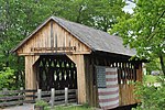
The Keniston Bridge is a historic covered bridge in Andover, New Hampshire, carrying Bridge Street over the Blackwater River. Built in 1882, it is of Town through truss construction, and is one of the few surviving 19th-century covered bridges in the state. It is also one of the only ones whose sides are not fully sheathed, exposing the trusses. The bridge was listed on the National Register of Historic Places in 1989.

Excerpt from the Wikipedia article Keniston Bridge (License: CC BY-SA 3.0, Authors, Images).

Keniston Bridge
Northern Rail Trail,

Geographical coordinates (GPS) Address Nearby Places
placeShow on map

Wikipedia: Keniston BridgeContinue reading on Wikipedia

Geographical coordinates (GPS)

Latitude Longitude
N 43.435 ° E -71.836666666667 °
placeShow on map

Address

Northern Rail Trail

Northern Rail Trail
03216
New Hampshire, United States
mapOpen on Google Maps

AndoverNH KenistonBridge
Share experience

Nearby Places

Hopkins Pond (New Hampshire)

Hopkins Pond (also known as Adder Pond) is a small pond located at the south foot of Ragged Mountain, in the town of Andover, New Hampshire, United States. It lies at an elevation of 644 feet (196 m). The pond is part of Proctor Academy's 2,500-acre (10 km2) campus in Andover and is jointly managed by Proctor and the New Hampshire Fish and Game Department. The pond area is open to the public for non-motorized boat travel, fishing and hiking. This shallow pond has an average depth of 6 feet (1.8 m), is 15 feet (4.6 m) deep at the deepest point, and covers a total area of 27 acres (11 ha). It empties eastward into Mountain Brook below Elbow Pond. Mountain Brook, in turn, is a tributary of the Blackwater River, which flows via the Contoocook River and Merrimack River to the Gulf of Maine (Atlantic Ocean) at Newburyport, Massachusetts. Hopkins Pond sits within the Merrimack River watershed, and is floristically considered part of the Sunapee Uplands sub-region of the Lower New England-Northern Piedmont Ecoregion, as defined by The Nature Conservancy, and the New England-Acadian Forest Ecoregion, as defined by the World Wildlife Fund.The north shore of Hopkins Pond can be accessed from the west by Middle Hopkins Pond Trail. The south shore can be accessed from Lower Hopkins Pond Trail. Both shores can be accessed from the east by an NH Fish and Game access road off Elbow Pond Road. Observed species of fish in the pond include rainbow trout and brook trout.