place

City of London Academy, Southwark

2003 establishments in EnglandAcademies in the London Borough of SouthwarkEducational institutions established in 2003London school stubsSecondary schools in the London Borough of Southwark
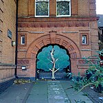
City of London Academy, Southwark geograph.org.uk 1449474

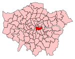
City of London Academy, Southwark is a co-educational secondary school and sixth form with academy status, located in the Bermondsey area of the London Borough of Southwark, England.The school was first opened in 2003, and moved to a new building in 2005. The building was designed by Studio E Architects and built by Willmott Dixon. The school is sponsored by the City of London Corporation, along with City Academy, Hackney and City of London Academy Islington. The school has specialisms in Business and Enterprise and in Sport, and the school teaches the non-curricular subject Business Studies, designed to help pupils become entrepreneurs. A unique aspect of The City of London Academy, Southwark is that students pay for their lunches with a Prepaid MasterCard debit card that parents top up using a smartphone app. Students can also pay for their meals with a fingerprint scanner.

Excerpt from the Wikipedia article City of London Academy, Southwark (License: CC BY-SA 3.0, Authors, Images).

City of London Academy, Southwark
Abercorn Way, London Bermondsey (London Borough of Southwark)

Geographical coordinates (GPS) Address External links Nearby Places
placeShow on map

Wikipedia: City of London Academy, SouthwarkContinue reading on Wikipedia

Geographical coordinates (GPS)

Latitude Longitude
N 51.4892 ° E -0.0647 °
placeShow on map

Address

City of London Academy

Abercorn Way
SE1 5HE London, Bermondsey (London Borough of Southwark)
England, United Kingdom
mapOpen on Google Maps

linkWikiData (Q16829700)
linkOpenStreetMap (13599389)

City of London Academy, Southwark geograph.org.uk 1449474
Share experience

Nearby Places

The Bermondsey Lion
The Bermondsey Lion

The Bermondsey Lion is a sculpture in The Blue, Bermondsey, London, created by Kevin Boys for Southwark Council. It was unveiled on 16 July 2011.The plaque on the plinth of the statue states: The Bermondsey Lion has been an enduring symbol of the area for centuries and initially represented the once powerful Bermondsey Abbey (hence the crozier placed in the front right paw). The Abbey was located around the (modern day) junction of Tower Bridge Road with Long Lane and Abbey Street, although it's [sic] lands extended over a vast area. The lion forms the major part of the former Metropolitan Borough of Bermondsey's coat of arms which were granted in March 1901 by the College of Heralds and was used until it's [sic] merger into the modern day London Borough of Southwark on April 1st 1965. the old metropolitan borough was established from the parishes of Bermondsey, Rotherhithe, St Olave, St John Horsleydown and St Thomas Southwark. The symbols represented on the coat of arms are the lion with crozier for Bermondsey, the ship representing Rotherhithe's one time main industry and the axe and crown of King Olaf which was formerly used by the St Olave District Board of works. The legend Prosunt Gentibus Artes translated means Arts Profit the People and originally came from the former coat of arms for the vestry of Rotherhithe. This representation of the Bermondsey Lion created by Kevin Boys for Southwark Council was unveiled by the Worshipful the Mayor of Southwark, councillor Lorraine Lauder MBE, Flo Weller and Kyle Quin on 16th July 2011.

Old Kent Road
Old Kent Road

Old Kent Road is a major thoroughfare in South East London, England, passing through the London Borough of Southwark. It was originally part of an ancient trackway that was paved by the Romans and used by the Anglo-Saxons who named it Wæcelinga Stræt (Watling Street). It is now part of the A2, a major road from London to Dover. The road was important in Roman times linking London to the coast at Richborough and Dover via Canterbury. It was a route for pilgrims in the Middle Ages as portrayed in Chaucer's Canterbury Tales, when Old Kent Road was known as Kent Street. The route was used by soldiers returning from the Battle of Agincourt. In the 16th century, St Thomas-a-Watering on Old Kent Road was a place where religious dissenters and those found guilty of treason were publicly hanged. The road was rural in nature and several coaching inns were built alongside it. In the 19th century it acquired the name Old Kent Road and several industrial premises were set up to close to the Surrey Canal and a major business, the Metropolitan Gas Works was developed. In the 20th century, older property was demolished for redevelopment and Burgess Park was created. The Old Kent Road Baths opened around 1905 had Turkish and Russian bath facilities. In the 21st century, several retail parks and premises typical of out-of-town development have been built beside it while public houses have been redeveloped for other purposes. The road is celebrated in the music hall song "Knocked 'em in the Old Kent Road", describing working-class London life. It is the first property, and one of the two cheapest, on the London Monopoly board and the only one south of the River Thames.