Sunray Agricultural Historic District
Buildings and structures in Chesapeake, VirginiaColonial Revival architecture in VirginiaHampton Roads, Virginia Registered Historic Place stubsHistoric districts on the National Register of Historic Places in VirginiaNRHP infobox with nocat ... and 2 more
National Register of Historic Places in Chesapeake, VirginiaUse mdy dates from August 2023

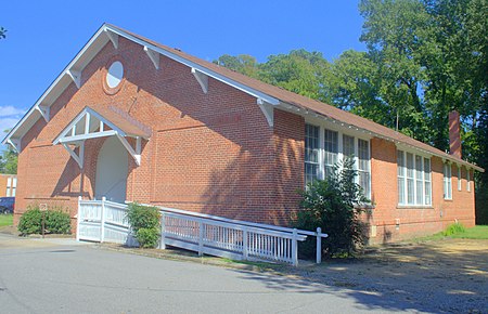
Sunray Agricultural Historic District is a national historic district located at Chesapeake, Virginia. The district encompasses 188 contributing buildings, 90 contributing sites, 2 contributing structures, and 1 contributing object in the early 20th-century immigrant farming community of Sunray. It includes early 20th century vernacular farmhouses, agricultural buildings, Sunray School (1922), and St. Mary's Catholic Church (1915-1916). The district also includes a tidal ditch system, the abandoned Virginian Railway Tracks (1909), and agricultural fields laid out with the platting of 1908.
Excerpt from the Wikipedia article Sunray Agricultural Historic District (License: CC BY-SA 3.0, Authors, Images).Sunray Agricultural Historic District
Homestead Road, Chesapeake
Geographical coordinates (GPS) Address Nearby Places Show on map
Geographical coordinates (GPS)
| Latitude | Longitude |
|---|---|
| N 36.780833333333 ° | E -76.411111111111 ° |
Address
Homestead Road 605
23321 Chesapeake
Virginia, United States
Open on Google Maps


