place

The Rectory, Chew Stoke
Clergy houses in EnglandGrade II* listed buildings in Bath and North East SomersetGrade II* listed houses in SomersetHouses completed in 1529Religious buildings and structures completed in 1529
Rectorychewstoke
Rectorychewstoke

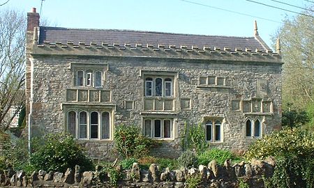
The Rectory in Chew Stoke, Somerset, England was built in 1529. It is a Grade II* listed building.It was built in 1529 for Sir John Barry, who was the rector between 1524 and 1546 of the nearby St Andrew's Church. It has undergone substantial renovations including the addition of a clock tower for the Rev. W.P. Wait, which has since been removed and further alterations c.1876 for Rev. J. Ellershaw. The building has an ornate south front with carvings of shields bearing the coat of arms of the St Loe family, who were once chief landowners in the area, alone or impaled with arms of Fitzpane, Ancell, de la Rivere and Malet. Towards the end of the 18th century a new rectory was built in the village and this building became a private house. In 1945 it started to be used again as the rectory. It was sold by the church in 2008 and is now a private dwelling again.

Excerpt from the Wikipedia article The Rectory, Chew Stoke (License: CC BY-SA 3.0, Authors, Images).

The Rectory, Chew Stoke
Pilgrim's Way, Bristol

Geographical coordinates (GPS) Address External links Nearby Places
placeShow on map

Wikipedia: The Rectory, Chew StokeContinue reading on Wikipedia

Geographical coordinates (GPS)

Latitude Longitude
N 51.354444444444 ° E -2.6358333333333 °
placeShow on map

Address

Pilgrim's Way
BS40 8TX Bristol
England, United Kingdom
mapOpen on Google Maps

linkWikiData (Q15979568)
linkOpenStreetMap (1093778106)

Rectorychewstoke
Rectorychewstoke
Share experience

Nearby Places

Littleton gunpowder works

Littleton gunpowder works between Winford and Chew Magna in the English county of Somerset, started gunpowder production around 1650 and continued until approximately 1820. It is a listed as a scheduled monument.The powder mill opened around 1740 following the expansion of the port in Bristol and increased availability of saltpetre from India. The mill was controlled by merchants based in the city and supplied gunpowder to ships sailing from the port. A previous warehouse, on the site where Bristol Temple Meads railway station now stands was considered too dangerous in the city. Despite a fire in 1755 the Littleton works expanded to become the largest gunpowder producing works in South West England by the middle of the 18th century. There was some association with another gunpowder mill at Woolley near Bath and the purchase and conversion of a snuff mill at nearby Stanton Drew was considered. It closed in the 1820s after the end of the Napoleonic Wars. It was powered by an overshot water wheel on Winford Brook a tributary of the River Chew.Some of the buildings remain intact, while others are ruined. The farmhouse was built in the mid 16th century but has been added to and revised in the 17th, 18th and 19th centuries. It is a Grade II* listed building, as is the 17th century barn. Powder Mill Cottage was built in the 18th century as the cooperage for the powder mill. The clock tower which was part of the works was originally attached to a chapel or office.

Chew Valley

The Chew Valley is an affluent area in North Somerset, England, named after the River Chew, which rises at Chewton Mendip, and joins the River Avon at Keynsham. Technically, the area of the valley is bounded by the water catchment area of the Chew and its tributaries; however, the name Chew Valley is often used less formally to cover other nearby areas, for example, Blagdon Lake and its environs, which by a stricter definition are part of the Yeo Valley. The valley is an area of rich arable and dairy farmland, interspersed with a number of villages. The landscape consists of the valley of the River Chew and is generally low-lying and undulating. It is bounded by higher ground ranging from Dundry Down to the north, the Lulsgate Plateau to the west, the Mendip Hills to the south and the Hinton Blewett, Temple Cloud, Clutton and Marksbury plateau areas to the east. The valley's boundary generally follows the top of scarp slopes except at the southwestern and southeastern boundaries where flat upper areas of the Chew Valley grade gently into the Yeo Valley and eastern Mendip Hills respectively. The River Chew was dammed in the 1950s to create Chew Valley Lake, which provides drinking water for the nearby city of Bristol and surrounding areas. The lake is a prominent landscape feature of the valley, a focus for recreation, and is internationally recognised for its nature conservation interest, because of the bird species, plants and insects. The area falls into the domains of councils including Bath and North East Somerset, North Somerset and Mendip. Part of the area falls within the Mendip Hills Area of Outstanding Natural Beauty. Most of the undeveloped area is within the Bristol/Bath Green Belt. Many of the villages date back to the time of the Domesday Book and there is evidence of human occupation since the Stone Age. There are hundreds of listed buildings with the churches being Grade I listed. The main commercial centre is Chew Magna.