place

Dundry Main Road South Quarry
Bath and North East SomersetQuarries in SomersetSites of Special Scientific Interest in AvonSites of Special Scientific Interest notified in 1974Use British English from February 2023
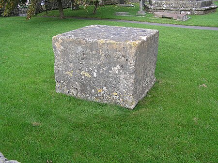
Geograph 2141759 Dundry slab

Dundry Main Road South Quarry (grid reference ST566654) is a 0.7 hectare geological Site of Special Scientific Interest near the village of East Dundry, North Somerset, notified in 1974. The quarry was cited in the 19th century by d'Orbigny as the English "type section" for the Inferior Oolite. Dundry has long been a famous palaeontological and stratigraphic locality. The type locality for many species of molluscs and brachiopods, as well as other lesser groups, it is renowned as one of the world's most fossiliferous exposures with well over two hundred species recorded. The Main Road Quarry exposes a fine section in the Middle and Upper Inferior Oolite, with the rocks lying stratigraphically below them visible at Barns Batch Spinney. The former characterised by a typically southern English-Normandy fauna, including the rich ammonite occurrences of the "Brown iron-shot", and the latter by contrasting faunas of Cotswold aspect. This contrast is direct evidence for movements of the Mendip Axis in Middle Jurassic times, making this an outstanding site for its bearing on studies of palaeogeography.

Excerpt from the Wikipedia article Dundry Main Road South Quarry (License: CC BY-SA 3.0, Authors, Images).

Dundry Main Road South Quarry
Wells Road,

Geographical coordinates (GPS) Address Nearby Places
placeShow on map

Wikipedia: Dundry Main Road South QuarryContinue reading on Wikipedia

Geographical coordinates (GPS)

Latitude Longitude
N 51.38598 ° E -2.62506 °
placeShow on map

Address

Wells Road

Wells Road
BS41 8NQ
England, United Kingdom
mapOpen on Google Maps

Geograph 2141759 Dundry slab
Share experience

Nearby Places

Withywood
Withywood

Withywood is a suburban neighbourhood of Bristol, England. It is situated on the southern border of the city, between Hartcliffe and Bishopsworth, just north of Dundry Hill. It is a large estate, begun in the 1950s. Withywood has a number of primary schools: Fair Furlong, Four Acres, Gay Elms and Merchants Academy. There is a secondary school, Merchants Academy, which opened in November 2008, before the demolition of the former Withywood Community School. All of the schools have sports fields and grounds. They have also been a registered charity since 1996. Queen's Road has a number of shops and the Amelia Nutt Health Clinic at the Withywood Centre. Four Acres road also has shops directly opposite Sherrin Way bus terminus (the end of the journey) next to 'The Rusham' retirement homes. It has a pub, from Elm Tree. Between Sherrin Way and The Coppice, runs the River Malago. This disappears into a culvert where the stream meets Four Acres. A big regeneration program is taking place around the area, new apartments on Hengrove Way and further development of The Junction shopping complex, and a proposal of a swimming pool and leisure complex alongside Cineworld, all within walking distance of Withywood. The Dundry View Neighbourhood Partnership works with residents in Bedminster Down, Bishopsworth, Hartcliffe, Headley Park, Highridge, Teyfant, Uplands, Whitchurch Park and Withywood. For elections to Bristol City Council, the area is part of Hartcliffe and Withywood electoral ward.

Littleton gunpowder works

Littleton gunpowder works between Winford and Chew Magna in the English county of Somerset, started gunpowder production around 1650 and continued until approximately 1820. It is a listed as a scheduled monument.The powder mill opened around 1740 following the expansion of the port in Bristol and increased availability of saltpetre from India. The mill was controlled by merchants based in the city and supplied gunpowder to ships sailing from the port. A previous warehouse, on the site where Bristol Temple Meads railway station now stands was considered too dangerous in the city. Despite a fire in 1755 the Littleton works expanded to become the largest gunpowder producing works in South West England by the middle of the 18th century. There was some association with another gunpowder mill at Woolley near Bath and the purchase and conversion of a snuff mill at nearby Stanton Drew was considered. It closed in the 1820s after the end of the Napoleonic Wars. It was powered by an overshot water wheel on Winford Brook a tributary of the River Chew.Some of the buildings remain intact, while others are ruined. The farmhouse was built in the mid 16th century but has been added to and revised in the 17th, 18th and 19th centuries. It is a Grade II* listed building, as is the 17th century barn. Powder Mill Cottage was built in the 18th century as the cooperage for the powder mill. The clock tower which was part of the works was originally attached to a chapel or office.