place

Chew Stoke

Civil parishes in SomersetUse British English from February 2012Villages in Bath and North East Somerset
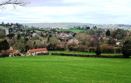
Chewstokevillagescape

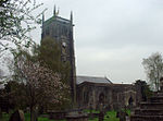
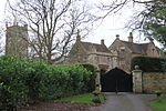
Chew Stoke is a small village and civil parish in the affluent Chew Valley, in Somerset, England, about 8 miles (13 km) south of Bristol and 10 miles north of Wells. It is at the northern edge of the Mendip Hills, a region designated by the United Kingdom as an Area of Outstanding Natural Beauty, and is within the Bristol/Bath green belt. The parish includes the hamlet of Breach Hill, which is approximately 2 miles (3.2 km) southwest of Chew Stoke itself. Chew Stoke has a long history, as shown by the number and range of its heritage-listed buildings. The village is at the northern end of Chew Valley Lake, which was created in the 1950s, close to a dam, pumping station, sailing club, and fishing lodge. A tributary of the River Chew, which rises in Strode, runs through the village. The population of 991 is served by one shop, one working public house, a primary school and a bowling club. Together with Chew Magna, it forms the ward of Chew Valley North in the unitary authority of Bath and North East Somerset. Chew Valley School and its associated leisure centre are less than a mile (1.6 km) from Chew Stoke. The village has some areas of light industry but is largely agricultural; many residents commute to nearby cities for employment.

Excerpt from the Wikipedia article Chew Stoke (License: CC BY-SA 3.0, Authors, Images).

Chew Stoke
School Lane, Bristol

Geographical coordinates (GPS) Address Nearby Places
placeShow on map

Wikipedia: Chew StokeContinue reading on Wikipedia

Geographical coordinates (GPS)

Latitude Longitude
N 51.3507 ° E -2.6383 °
placeShow on map

Address

School Lane
BS40 8UU Bristol
England, United Kingdom
mapOpen on Google Maps

Chewstokevillagescape
Share experience

Nearby Places

Chew Valley

The Chew Valley is an affluent area in North Somerset, England, named after the River Chew, which rises at Chewton Mendip, and joins the River Avon at Keynsham. Technically, the area of the valley is bounded by the water catchment area of the Chew and its tributaries; however, the name Chew Valley is often used less formally to cover other nearby areas, for example, Blagdon Lake and its environs, which by a stricter definition are part of the Yeo Valley. The valley is an area of rich arable and dairy farmland, interspersed with a number of villages. The landscape consists of the valley of the River Chew and is generally low-lying and undulating. It is bounded by higher ground ranging from Dundry Down to the north, the Lulsgate Plateau to the west, the Mendip Hills to the south and the Hinton Blewett, Temple Cloud, Clutton and Marksbury plateau areas to the east. The valley's boundary generally follows the top of scarp slopes except at the southwestern and southeastern boundaries where flat upper areas of the Chew Valley grade gently into the Yeo Valley and eastern Mendip Hills respectively. The River Chew was dammed in the 1950s to create Chew Valley Lake, which provides drinking water for the nearby city of Bristol and surrounding areas. The lake is a prominent landscape feature of the valley, a focus for recreation, and is internationally recognised for its nature conservation interest, because of the bird species, plants and insects. The area falls into the domains of councils including Bath and North East Somerset, North Somerset and Mendip. Part of the area falls within the Mendip Hills Area of Outstanding Natural Beauty. Most of the undeveloped area is within the Bristol/Bath Green Belt. Many of the villages date back to the time of the Domesday Book and there is evidence of human occupation since the Stone Age. There are hundreds of listed buildings with the churches being Grade I listed. The main commercial centre is Chew Magna.

Littleton gunpowder works

Littleton gunpowder works between Winford and Chew Magna in the English county of Somerset, started gunpowder production around 1650 and continued until approximately 1820. It is a listed as a scheduled monument.The powder mill opened around 1740 following the expansion of the port in Bristol and increased availability of saltpetre from India. The mill was controlled by merchants based in the city and supplied gunpowder to ships sailing from the port. A previous warehouse, on the site where Bristol Temple Meads railway station now stands was considered too dangerous in the city. Despite a fire in 1755 the Littleton works expanded to become the largest gunpowder producing works in South West England by the middle of the 18th century. There was some association with another gunpowder mill at Woolley near Bath and the purchase and conversion of a snuff mill at nearby Stanton Drew was considered. It closed in the 1820s after the end of the Napoleonic Wars. It was powered by an overshot water wheel on Winford Brook a tributary of the River Chew.Some of the buildings remain intact, while others are ruined. The farmhouse was built in the mid 16th century but has been added to and revised in the 17th, 18th and 19th centuries. It is a Grade II* listed building, as is the 17th century barn. Powder Mill Cottage was built in the 18th century as the cooperage for the powder mill. The clock tower which was part of the works was originally attached to a chapel or office.

Plaster's Green Meadows

Plaster's Green Meadows (grid reference ST532611) is a 4.3 hectare biological Site of Special Scientific Interest near the village of Nempnett Thrubwell, Bath and North East Somerset, notified in 1989. This is an area of unimproved and traditionally managed species-rich meadows which support a neutral grassland community of a type which is now rare throughout Britain. The site is situated on the slopes fringing the Lias Tablelands and is underlain by Rhaetic clays and, lower down the slope Keuper Red Marl. The slowly permeable clay soils are slightly calcareous in nature and this is reflected in elements of the flora. The site is characterised by the nationally rare Common Knapweed (Centaurea nigra) and Crested Dog’s-tail (Cynosurus cristatus) and dominant grasses include Sweet Vernal-grass (Anthoxanthum odoratum), Crested Dog’s-tail and Yorkshire Fog (Holcus lanatus), while Quaking Grass (Briza media) and Yellow Oat-grass (Trisetum flavescens) are also frequent. There is a high component of herb species throughout the meadows including Saw-wort (Serratuta tinctoria), Dyer’s Greenweed (Genista tinctoria), Common Knapweed, Pepper-saxifrage (Silaum silaus), Devil’s-bit Scabious (Succisa pratensis), Betony (Stachys officinalis) and Spiny Restharrow (Ononis spinosa). The calcareous nature of the soil is reflected by the presence of Cowslip (Primula veris), Fairy Flax (Linum catharticum), Glaucous Sedge (Carex flacca), Lady’s Bedstraw (Galium verum) and occasional Salad Burnet (Sanguisorba minor). The meadows are bounded by hedges supporting numerous species including Hawthorn (Crataegus monogyna), Wych Elm (Ulmus glabra), English Elm (Ulmus procera), Hazel (Corylus avellana) and Field Maple (Acer campestre). Hedgerow trees include Ash (Fraxinus excelsior), Sweet Chestnut (Castanea sativa), Holly (Ilex aquifolium) and Oak (Quercus spp.).