Hounslow Heath
Heaths of the United KingdomHistory of MiddlesexLocal nature reserves in Greater LondonNature reserves in the London Borough of HounslowParks and open spaces in the London Borough of Hounslow

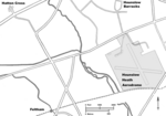
Hounslow Heath is a local nature reserve in the London Borough of Hounslow and at a point borders Richmond upon Thames. The public open space, which covers 200 acres (80 ha), is all that remains of the historic Hounslow Heath which covered more than 4,000 acres (1,600 ha). The present day area is bounded by A315 Staines Road, A3063 Wellington Road South, A314 Hanworth Road, and the River Crane.
Excerpt from the Wikipedia article Hounslow Heath (License: CC BY-SA 3.0, Authors, Images).Hounslow Heath
Hanworth Road, London Whitton (London Borough of Richmond upon Thames)
Geographical coordinates (GPS) Address External links Nearby Places Show on map
Geographical coordinates (GPS)
| Latitude | Longitude |
|---|---|
| N 51.454722222222 ° | E -0.385 ° |
Address
Hounslow Heath
Hanworth Road
TW4 5QL London, Whitton (London Borough of Richmond upon Thames)
England, United Kingdom
Open on Google Maps


