place

Aqua Anio Novus

1st-century establishments in Italy50s establishments in the Roman Empire52 establishmentsAncient Roman aqueducts in RomeBuildings and structures completed in the 1st century
CaligulaClaudius
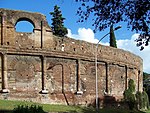
Porta Maggiore 21 09 2019

Aqua Anio Novus (Latin for "New Anio aqueduct") was an ancient Roman aqueduct. Like the Aqua Claudia, it was begun by emperor Caligula in 38 AD and completed in 52 AD by Claudius, who dedicated them both on August 1. Together with the Aqua Anio Vetus, Aqua Marcia and Aqua Claudia, it is regarded as one of the "four great aqueducts of Rome."

Excerpt from the Wikipedia article Aqua Anio Novus (License: CC BY-SA 3.0, Authors, Images).

Aqua Anio Novus
Piazzale Labicano, Rome Municipio Roma VII

Geographical coordinates (GPS) Address Nearby Places
placeShow on map

Wikipedia: Aqua Anio NovusContinue reading on Wikipedia

Geographical coordinates (GPS)

Latitude Longitude
N 41.891388888889 ° E 12.515277777778 °
placeShow on map

Address

Sepolcro del fornaio Eurisace

Piazzale Labicano
00182 Rome, Municipio Roma VII
Lazio, Italy
mapOpen on Google Maps

Porta Maggiore 21 09 2019
Share experience

Nearby Places

Tomb of Eurysaces the Baker

The tomb of Marcus Vergilius Eurysaces the baker is one of the largest and best-preserved freedman funerary monuments in Rome. Its sculpted frieze is a classic example of the "plebeian style" in Roman sculpture. Eurysaces built the tomb for himself and perhaps also his wife Atistia around the end of the Republic (ca. 50–20 BC). Located in a prominent position just outside today's Porta Maggiore, the tomb was transformed by its incorporation into the Aurelian Wall; a tower subsequently erected by Honorius covered the tomb, the remains of which were exposed upon its removal by Gregory XVI in 1838. What is particularly significant about this extravagant tomb is that it was built by a freedman, a former slave. Three sides of the slightly trapezoidal structure remain largely intact. All have the same form, with over a plain lower storey, now mostly below ground level but exposed, a storey consisting of pairs of engaged columns between flat slabs, all crammed together with no space in between. The effect is far from the classical orders; at the corners the slabs turn to pilasters rising at the top level to unorthodox capitals combining scrolls at the sides with plant forms in the centre. There are unusual circular openings in the topmost storey, now thought to represent kneading-basins or grain-measuring vessels. Below a cornice is the frieze, with continuous scenes in relief showing the operation of the bakery where Eurysaces made what was evidently a considerable fortune. Reconstructions imagine a gently rising roof above this, now lost.

Temple of Minerva Medica (nymphaeum)

The Temple of Minerva Medica is a ruined nymphaeum of Imperial Rome which dates to the 4th century. It is located between the Via Labicana and Aurelian Walls and just inside the line of the Anio Vetus. Once part of the Horti Liciniani on the Esquiline Hill, it now faces the modern Via Giolitti. It was once thought to be the temple to Minerva Medica ("Minerva the Doctor") mentioned by Cicero and other sources. The decagonal structure in opus latericium is relatively well preserved, though the full dome collapsed in 1828. It is surrounded on three sides with other chambers added at a later date. There is no mention of it in ancient literature or inscriptions. The structure represents a transition in Roman secular architecture between the octagonal dining room of the Domus Aurea and the dome of the Pantheon, and the architecture of nearby Byzantine churches. The diameter of the hall was about 24 meters, and the height was 33 meters — important from the structural point of view, especially for the ribs in the dome. In the interior, there are nine niches besides the entrance; and above these are ten corresponding round-arched windows. Both the interior and exterior walls were once covered with marble.In Flavio Biondo's 15th-century Roma Instaurata, these ruins are called Le Galluzze, a name of uncertain meaning that had been applied earlier to some ruins near the basilica of Santa Croce in Gerusalemme. Its misidentification as the Republican-era temple dates to the 17th century, based on the incorrect impression that the Athena Giustiniani had been found there.

San Lorenzo (Rome)

San Lorenzo is an urban zone in Rome, Italy. Administratively it was part of both Municipio II and Quarter VI Tiburtino. It occupies roughly the two sides of the early stretch of Via Tiburtina, starting from Termini railway station and ending at the Verano area. The latter includes the ancient basilica of San Lorenzo fuori le Mura, from which the district takes its name. Originally a working-class neighbourhood (its inhabitants were mostly workers of the Wuehrer Brewery and the freight yard), it has been a popular, left-oriented area. During World War II San Lorenzo was heavily bombed by Allied planes (on 1943-07-19); the only massive bombing of Rome during the war (though not the only air raid on the city), it aimed at disrupting the railway communication pivoting on the nearby huge freight yard; however, it caused also extensive damage to the buildings of the district (including the Policlinico Umberto I and the basilica itself) and killing some 1,500 people. Maria Montessori's first 3-6 age program was started in San Lorenzo in 1907. Today San Lorenzo, due to the vicinity of the La Sapienza University, is increasingly assuming the character of a student and young artist district. Pizzerias, bookshops, boutiques and other modern places are subsequently replacing the old popular workshops and small markets. The city is zone of many bars, cafes, restaurants and nightclubs which host also a different cultural discussions and art exhibitions.