Hundwiler Höhi
Appenzell AlpsAppenzell Ausserrhoden–Appenzell Innerrhoden borderMountains of Appenzell AusserrhodenMountains of Appenzell InnerrhodenMountains of Switzerland ... and 4 more
Mountains of the AlpsOne-thousanders of SwitzerlandSwitzerland geography stubsSwitzerland mountain stubs

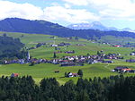
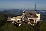
The Hundwiler Höhi (1,306 m) is a mountain of the Appenzell Alps, located on the border between the Swiss cantons of Appenzell Ausserrhoden and Appenzell Innerrhoden. It is situated between Hundwil and Gonten. The summit is easily accessible from every side of the mountain and is a popular vantage point over the Säntis, the Alpstein massif and Lake Constance. A mountain hut is located near the top.
Excerpt from the Wikipedia article Hundwiler Höhi (License: CC BY-SA 3.0, Authors, Images).Hundwiler Höhi
Hundwilerhöhe,
Geographical coordinates (GPS) Address Nearby Places Show on map
Geographical coordinates (GPS)
| Latitude | Longitude |
|---|---|
| N 47.340833333333 ° | E 9.3333333333333 ° |
Address
Hundwilerhöhe
9064
Appenzell Ausserrhoden, Switzerland
Open on Google Maps


