Bottom Wood
Chiltern HillsForests and woodlands of Buckinghamshire

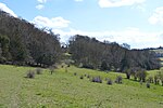
Bottom Wood is a 14.5-hectare (36-acre) woodland in the English county of Buckinghamshire, located just north of the A40 near the hamlet of Studley Green. Since 1984, the wood has been owned by the Chiltern Society, which manages it as a nature reserve with the help of volunteers. Although an ancient woodland, most of the trees in the wood date from the end of the 1940s or later, as much of the wood was felled during the Second World War to produce Bryant and May matches. The wood is now home to a diverse range of flora and fauna, including rare species of butterfly and moth.
Excerpt from the Wikipedia article Bottom Wood (License: CC BY-SA 3.0, Authors, Images).Bottom Wood
Green End Road,
Geographical coordinates (GPS) Address Nearby Places Show on map
Geographical coordinates (GPS)
| Latitude | Longitude |
|---|---|
| N 51.654 ° | E -0.851 ° |
Address
Green End Road
HP14 4BZ
England, United Kingdom
Open on Google Maps


