Beacon Hill, Norfolk

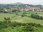
Beacon Hill is the highest point in the English county of Norfolk. The hill is located 0.75 miles (1.2 km) south of the village of West Runton on the North Norfolk coast. At its summit the hill is 105 metres (344 ft) above sea level. The hill is also known as Roman Camp. The summit and surrounding woodlands are now in the care of the National Trust. A track, named Calves Well Lane, running west from Sandy Lane leads to a car park which is maintained by donations made to the National Trust collection box provide on the edge of the car park. Litter bins and benches make Beacon Hill an ideal location for picnics. There are several footpaths to follow across the area.
Excerpt from the Wikipedia article Beacon Hill, Norfolk (License: CC BY-SA 3.0, Authors, Images).Beacon Hill, Norfolk
Holgate Lane, North Norfolk Runton
Geographical coordinates (GPS) Address Nearby Places Show on map
Geographical coordinates (GPS)
| Latitude | Longitude |
|---|---|
| N 52.925 ° | E 1.2514 ° |
Address
Holgate Lane
Holgate Lane
NR27 9NE North Norfolk, Runton
England, United Kingdom
Open on Google Maps


