place

Jervis Bay National Park

1995 establishments in AustraliaIUCN Category IIJervis Bay TerritoryNational parks of New South WalesNew South Wales protected area stubs
Use Australian English from September 2014
JervisBay NationalPark NSW 002

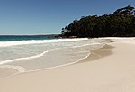
Jervis Bay National Park, formerly known as Jervis Bay National Park (NSW), consists of several protected areas on the western and northern foreshores of Jervis Bay, on the south coast of New South Wales. The park is close to the town of Huskisson and includes Hyams Beach, renowned for its white sand, whale watching and fishing opportunities.Visitor facilities are provided in the Greenfield Beach section of the park, including toilets, showers and walking tracks. The park was gazetted in 1995 as "Jervis Bay National Park (NSW)" to avoid confusion with nearby Booderee National Park in the Jervis Bay Territory, then known by the same name. Part of Jervis Bay itself is reserved as Jervis Bay Marine Park. The Aboriginal heritage in the park dates back thousands of years and they still feel a strong connection to the land.Jervis Bay National Park is 48.57 km2 in size and is managed by the NSW Department of Planning & Environment. The average altitude of the terrain is 16 metres.

Excerpt from the Wikipedia article Jervis Bay National Park (License: CC BY-SA 3.0, Authors, Images).

Jervis Bay National Park
Red Point Road, Shoalhaven City Council

Geographical coordinates (GPS) Address Nearby Places
placeShow on map

Wikipedia: Jervis Bay National ParkContinue reading on Wikipedia

Geographical coordinates (GPS)

Latitude Longitude
N -34.987222222222 ° E 150.75638888889 °
placeShow on map

Address

Red Point Road

Red Point Road
2540 Shoalhaven City Council, Kinghorne
New South Wales, Australia
mapOpen on Google Maps

JervisBay NationalPark NSW 002
Share experience

Nearby Places

Callala Bay
Callala Bay

Callala Bay is a small town on the South Coast of New South Wales, Australia in the City of Shoalhaven. The town is situated on the northern shore of Jervis Bay about 20 minutes drive from Nowra and 10 minutes from Culburra Beach. Callala Bay has an approximate elevation of 13 metres (43 ft) above sea level, and is located inland from Callala Point, a headland facing the Tasman Sea. Nearby settlements include Callala Beach and Myola to the south-west, Currarong to the south-east and Culburra Beach to the north-east. Local facilities and community activities include: a safe harbour jetty sailing club boat ramp medical centre primary school child care and pre-school centre faith groups soccer club skateboard park netball/basketball courts community centre (available for hire) NSW Rural Fire Service - Callala Bay a small shopping centre (Australia Post, supermarket, chemist, baker, butcher, cafe, take away, real estate agents, cellars) shared pathway around the headland small group activities (aqua exercise group, craft, folk dance, yoga, over 50s' social group, garden club, Writers, Bushcare) regular bus service to Nowra, including for high school students.Profile statistics used by Shoalhaven City Council for planning purposes are located here Callala Bay is a short drive or flat bike ride from the popular Club Callala (Callala RSL Country Club) which hosts a challenging 18 hole golf course, two bowling greens, great food and nightly entertainment.