Steeple Barton

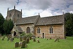
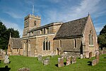
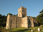
Steeple Barton is a civil parish and scattered settlement on the River Dorn in West Oxfordshire, about 8+1⁄2 miles (13.7 km) east of Chipping Norton, a similar distance west of Bicester and 9 miles (14 km) south of Banbury. Most of the parish's population lives in the village of Middle Barton, about 1 mile (1.6 km) northwest of the settlement of Steeple Barton. The 2011 Census recorded the parish's population as 1,523. Much of the parish's eastern boundary is formed by the former turnpike between Oxford and Banbury, now classified the A4260 road. The minor road between Middle Barton and Kiddington forms part of the western boundary. Field boundaries form most of the rest of the boundaries of the parish.
Excerpt from the Wikipedia article Steeple Barton (License: CC BY-SA 3.0, Authors, Images).Steeple Barton
Pack Lane, West Oxfordshire
Geographical coordinates (GPS) Address Nearby Places Show on map
Geographical coordinates (GPS)
| Latitude | Longitude |
|---|---|
| N 51.922 ° | E -1.351 ° |
Address
Pack Lane
Pack Lane
OX25 4QW West Oxfordshire
England, United Kingdom
Open on Google Maps


