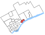
Pickering—Scarborough East (provincial electoral district)

Pickering—Scarborough East was a provincial electoral district in Ontario, Canada, that was represented in the Legislative Assembly of Ontario between 2007 and 2018. The district was created in 2003 from 44.1% of Pickering—Ajax—Uxbridge, 39.7% of Scarborough East, and 0.1% of Scarborough—Rouge River ridings. The district consisted of the southwest part of the city of Pickering and the southeast part of the Scarborough district of Toronto. Specifically, it consisted of the part of the City of Pickering lying south and west of a line drawn from the western city limit east along Finch Avenue, south along Valley Farm Road, northeast along Highway 401 and south along Brock Road to the southern city limit; and the part of the City of Toronto lying south and east of a line drawn from the eastern city limit west along Finch Avenue East, south along Meadowvale Road, west along Sheppard Avenue East, south along Morningside Avenue and southeast along Highland Creek to Lake Ontario. In 2018, the district was dissolved into Pickering—Uxbridge and Scarborough—Rouge Park.
Excerpt from the Wikipedia article Pickering—Scarborough East (provincial electoral district) (License: CC BY-SA 3.0, Authors, Images).Pickering—Scarborough East (provincial electoral district)
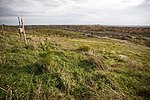
Mast Trail, Toronto Scarborough
Geographical coordinates (GPS) Address Nearby Places Show on map
Geographical coordinates (GPS)
| Latitude | Longitude |
|---|---|
| N 43.81 ° | E -79.14 ° |
Address
Mast Trail
Mast Trail
M1B 5S3 Toronto, Scarborough
Ontario, Canada
Open on Google Maps


